
The Hague topographic map
Interactive map
Click on the map to display elevation.
About this map
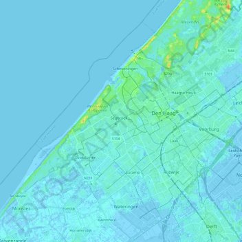
Name: The Hague topographic map, elevation, terrain.
Location: The Hague, South Holland, Netherlands (52.01485 4.18500 52.13504 4.42249)
Average elevation: 7 ft
Minimum elevation: -26 ft
Maximum elevation: 92 ft
Other topographic maps
Click on a map to view its topography, its elevation and its terrain.
Zuidland
Zuidland, Nissewaard, South Holland, Netherlands
Average elevation: 0 ft
Leidschendam
Leidschendam, Leidschendam-Voorburg, South Holland, Netherlands
Average elevation: 3 ft
Stellendam
Stellendam, Goeree-Overflakkee, South Holland, Netherlands
Average elevation: 0 ft
Nieuwerkerk aan den IJssel
Nieuwerkerk aan den IJssel, Zuidplas, South Holland, Netherlands
Average elevation: -10 ft
Capelle aan den IJssel
Capelle aan den IJssel, South Holland, Netherlands
Average elevation: -3 ft
Brielle
Netherlands > South Holland > Brielle
Brielle, South Holland, Netherlands
Average elevation: 7 ft
Sassenheim
Sassenheim, Teylingen, South Holland, Netherlands
Average elevation: 0 ft
Hellevoetsluis
Netherlands > South Holland > Hellevoetsluis
Hellevoetsluis, South Holland, Netherlands
Average elevation: 0 ft
Zevenhuizen
Netherlands > South Holland > Zevenhuizen
Zevenhuizen, Zuidplas, South Holland, Netherlands
Average elevation: -13 ft
Oegstgeest
Netherlands > South Holland > Oegstgeest
Oegstgeest, South Holland, Netherlands
Average elevation: 7 ft
Alphen aan den Rijn
Alphen aan den Rijn, South Holland, Netherlands
Average elevation: -3 ft
Dutch Harbour
Netherlands > South Holland > 's-Gravendeel
Dutch Harbour, 's-Gravendeel, Hoeksche Waard, South Holland, Netherlands, 3295XZ, Netherlands
Average elevation: 3 ft
Kaag
Netherlands > South Holland > Kaag
Kaag, Kaag en Braassem, South Holland, Netherlands
Average elevation: -7 ft
Zoetermeer
Netherlands > South Holland > Zoetermeer
Zoetermeer, South Holland, Netherlands
Average elevation: -10 ft
Wassenaar
Netherlands > South Holland > Wassenaar
Wassenaar, South Holland, Netherlands
Average elevation: 10 ft
Middelharnis
Netherlands > South Holland > Middelharnis
Middelharnis, Goeree-Overflakkee, South Holland, Netherlands
Average elevation: 0 ft
Capelle aan den IJssel
Netherlands > South Holland > Capelle aan den IJssel
Capelle aan den IJssel, South Holland, Netherlands, 2902LD, Netherlands
Average elevation: -3 ft
Papendrecht
Netherlands > South Holland > Papendrecht
Papendrecht, South Holland, Netherlands
Average elevation: 7 ft
Noordwijkerhout
Netherlands > South Holland > Noordwijk
Noordwijkerhout, Noordwijk, South Holland, Netherlands
Average elevation: 7 ft
Voorne-Putten
Voorne-Putten, South Holland, Netherlands
Average elevation: 3 ft
Ruigenhoek
Netherlands > South Holland > Noordwijk > De Zilk > Ruigenhoek
Ruigenhoek, De Zilk, Noordwijk, South Holland, Netherlands, 2191AH, Netherlands
Average elevation: 7 ft
Gouda
Netherlands > South Holland > Gouda
Gouda, Zuidplas, South Holland, Netherlands
Average elevation: -3 ft
Alphen aan den Rijn
Alphen aan den Rijn, South Holland, Netherlands
Average elevation: -7 ft
Hook of Holland
Hook of Holland, Rotterdam, South Holland, Netherlands
Average elevation: 7 ft
Nootdorp
Netherlands > South Holland > Pijnacker-Nootdorp > Nootdorp
Nootdorp, Pijnacker-Nootdorp, South Holland, Netherlands
Average elevation: -7 ft
Noordwijk
Netherlands > South Holland > Noordwijk
Noordwijk, South Holland, Netherlands
Average elevation: 3 ft
Vlaardingen
Netherlands > South Holland > Vlaardingen
Vlaardingen, South Holland, Netherlands
Average elevation: 3 ft
Westvoorne
Netherlands > South Holland > Westvoorne
Westvoorne, South Holland, Netherlands
Average elevation: 3 ft
Zwijndrecht
Netherlands > South Holland > Zwijndrecht
Zwijndrecht, South Holland, Netherlands
Average elevation: 3 ft
Kasteel van Rhoon
Netherlands > South Holland > Albrandswaard
Kasteel van Rhoon, Dorpsdijk, Rhoon, Albrandswaard, South Holland, Netherlands, 3161KD, Netherlands
Average elevation: 3 ft
Rockanje
Rockanje, Westvoorne, South Holland, Netherlands
Average elevation: 3 ft
Rijswijk
Netherlands > South Holland > Rijswijk
Rijswijk, South Holland, Netherlands
Average elevation: 7 ft
De Zilk
Netherlands > South Holland > Noordwijk
De Zilk, Noordwijk, South Holland, Netherlands
Average elevation: 7 ft
Capelle aan den IJssel
Netherlands > South Holland > Capelle aan den IJssel
Capelle aan den IJssel, Rotterdam, South Holland, Netherlands
Average elevation: -3 ft
Albrandswaard
Albrandswaard, South Holland, Netherlands
Average elevation: 7 ft
Meije
Netherlands > South Holland > Nieuwkoop
Meije, Nieuwkoop, South Holland, Netherlands, 2421NC, Netherlands
Average elevation: -3 ft
Alblasserdam
Netherlands > South Holland > Alblasserdam
Alblasserdam, South Holland, Netherlands
Average elevation: 3 ft
Barendrecht
Netherlands > South Holland > Barendrecht
Barendrecht, South Holland, Netherlands
Average elevation: 3 ft
Monster
Netherlands > South Holland > Monster
Monster, South Holland, Netherlands, 2681, Netherlands
Average elevation: 3 ft