Geolocate

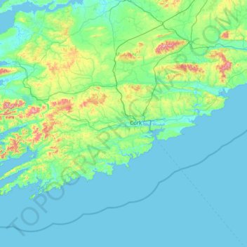
County Cork topographic map

Click on the map to display elevation.

County Cork

County Cork is located in the province of Munster, bordering Kerry to the west, Limerick to the north, Tipperary to the north-east and Waterford to the east. The county shares separate mountainous borders with Tipperary and Kerry. The terrain on the Kerry border was formed between 360 and 374 million years ago, as part of the rising of the MacGillycuddy's Reeks and Caha Mountains mountains ranges. This occurred during the Devonian period when Ireland was part of a larger continental landmass and located south of the equator. The region's topography of peaks and valleys are characterised by steep ridges formed during the Hercynian period of folding and mountain formation some 300 million years ago.

Wikipedia (CC-BY-SA 3.0)

About this map

Name: County Cork topographic map, elevation, terrain.

Location: County Cork, Munster, Ireland (51.38887 -10.30252 52.38779 -7.84115)

Average elevation: 256 ft

Minimum elevation: -3 ft

Maximum elevation: 3,245 ft

Other topographic maps

Click on a map to view its topography, its elevation and its terrain.

River Shannon

Ireland

Average elevation: 128 ft

Celbridge

Ireland > County Kildare > Celbridge

Average elevation: 210 ft

Cork

Ireland > County Cork > Cork

Average elevation: 308 ft

Dowth

Ireland

Average elevation: 105 ft

Blackrock

Ireland > County Dublin

Average elevation: 98 ft

Cromane

Ireland

Average elevation: 10 ft

Maghera Strand

Ireland

Average elevation: 121 ft

Knockdrin

Ireland

Average elevation: 315 ft

Ballycurry

Ireland

Average elevation: 584 ft

Ballyedmond

Ireland

Average elevation: 240 ft

Furry Glen

Ireland

Average elevation: 144 ft

Trout Lake

Ireland

Average elevation: 266 ft

Tory Hill

Ireland

Average elevation: 430 ft

Great Skellig

Ireland

Average elevation: 3 ft

Spinans Hill

Ireland

Average elevation: 801 ft

Gaulstown Castle

Ireland

Average elevation: 594 ft

Skeaghvasteen

Ireland

Average elevation: 318 ft

Tibberaghny Castle

Ireland

Average elevation: 59 ft

Myles Big Stone

Ireland

Average elevation: 292 ft

Kilkee Cliffs

Ireland

Average elevation: 62 ft

Dunlicky Point

Ireland

Average elevation: 59 ft

Doulus Head

Ireland

Average elevation: 52 ft

Bolus Head

Ireland

Average elevation: 92 ft

Galley Head

Ireland

Average elevation: 10 ft

Downeen Point

Ireland

Average elevation: 36 ft

Frower Point

Ireland

Average elevation: 66 ft

Knockadoon Head

Ireland

Average elevation: 20 ft

Mine Head

Ireland

Average elevation: 72 ft

Glendoo Mountain

Ireland

Average elevation: 1,575 ft

Crohy Head Sea Arch

Ireland

Average elevation: 92 ft

Dawros Bay

Ireland

Average elevation: 20 ft

Portacloy Bay

Ireland

Average elevation: 187 ft

Mace Head

Ireland

Average elevation: 10 ft

Doonbeg Head

Ireland

Average elevation: 105 ft

Lambs Head Bay

Ireland

Average elevation: 46 ft

Clifden Bay

Ireland

Average elevation: 135 ft

Galway Bay

Ireland

Average elevation: 0 ft

Dollymount

Ireland

Average elevation: 20 ft

Athlone

Ireland > County Westmeath > Athlone

Average elevation: 144 ft

Howth

Ireland > County Dublin

Average elevation: 26 ft

Bray Head

Ireland > County Wicklow

Average elevation: 144 ft

Clondalkin

Ireland > County Dublin

Average elevation: 226 ft

Malin Head

Ireland > County Donegal

Average elevation: 13 ft

Kilshanny

Ireland > County Clare

Average elevation: 171 ft

Galway City

Ireland > Galway City

Average elevation: 85 ft

Glendalough

Ireland > County Wicklow

Average elevation: 932 ft

Carlow

Ireland > Carlow

Average elevation: 207 ft

Clonakilty

Ireland > Clonakilty

Average elevation: 161 ft

Enniskerry

Ireland > County Wicklow > Enniskerry

Average elevation: 387 ft

Maynooth

Ireland > County Kildare > Maynooth

Average elevation: 217 ft

Clonalvy

Ireland > County Meath

Average elevation: 335 ft

Ardgroom

Ireland > County Cork

Average elevation: 184 ft

Drimoleague

Ireland > County Cork

Average elevation: 292 ft

Tourmakeady

Ireland > County Mayo

Average elevation: 187 ft

Upper Glanmire Bridge

Ireland > County Cork > Cork

Average elevation: 295 ft

Oldtown

Ireland > County Dublin

Average elevation: 217 ft

Ballivor

Ireland > County Meath

Average elevation: 220 ft

Firies

Ireland > County Kerry

Average elevation: 102 ft

Banagher

Ireland > County Offaly > Banagher

Average elevation: 141 ft

Newbliss

Ireland > County Monaghan > Newbliss

Average elevation: 377 ft

Caheraphuca

Ireland > County Cork

Average elevation: 466 ft

Glanbeg

Ireland > County Kerry

Average elevation: 833 ft

Carlanstown

Ireland > County Meath > Carlanstown

Average elevation: 197 ft

Barraduff

Ireland > County Kerry > Barraduff

Average elevation: 407 ft

Ladysbridge

Ireland > County Cork > Ladysbridge

Average elevation: 115 ft

Carlingford

Ireland > County Louth > Carlingford

Average elevation: 276 ft

An Easléim

Ireland > County Galway

Average elevation: 151 ft

Kerry Pike

Ireland > County Cork > Cork

Average elevation: 180 ft

Glenmacnass River

Ireland > County Wicklow

Average elevation: 1,424 ft

Fair Hill

Ireland > County Cork > Cork

Average elevation: 223 ft

Lisgoold

Ireland > County Cork

Average elevation: 367 ft

Staleen Lock - Lock 3

Ireland > County Meath

Average elevation: 164 ft

Ballincollig

Ireland > County Cork > Cork

Average elevation: 203 ft

Knockfadda

Ireland > County Kerry

Average elevation: 213 ft

Ballycastle

Ireland > County Mayo

Average elevation: 184 ft

Marino Point

Ireland > County Cork

Average elevation: 59 ft

Donoughmore

Ireland > County Cork

Average elevation: 600 ft

Garrykennedy

Ireland > County Tipperary

Average elevation: 184 ft

Castlegregory

Ireland > County Kerry

Average elevation: 56 ft

Shannon

Ireland > County Clare

Average elevation: 20 ft

Keeper Hill

Ireland > County Tipperary

Average elevation: 1,414 ft

Castleblakeney

Ireland > County Galway

Average elevation: 243 ft

Trim Castle Keep

Ireland > County Meath > Trim

Average elevation: 203 ft

Ennis

Ireland > County Clare > Ennis

Average elevation: 66 ft

Letterkenny

Ireland > County Donegal > Letterkenny

Average elevation: 305 ft

Kildare

Ireland > Kildare

Average elevation: 335 ft

Naas

Ireland > Naas

Average elevation: 335 ft

Dundalk

Ireland > County Louth > Dundalk

Average elevation: 52 ft

Drogheda

Ireland > County Louth > Drogheda

Average elevation: 125 ft

Clonmel

Ireland > County Tipperary > Clonmel

Average elevation: 348 ft

Dungarvan

Ireland > County Waterford

Average elevation: 98 ft

Mullingar

Ireland > County Westmeath

Average elevation: 331 ft

Bray

Ireland > County Wicklow > Bray

Average elevation: 190 ft

Swords

Ireland > County Dublin > Swords

The medieval town developed in a linear pattern along Main Street, in a roughly north-south direction. Swords has one of the best examples of this settlement pattern in the Dublin region. The round tower, 26m in height, is also an indicator of early Christian settlement. The Irish high king Brian Boru is said…
Average elevation: 92 ft
Killarney

Ireland > County Kerry > Killarney

Average elevation: 217 ft

Midleton

Ireland > Midleton

Average elevation: 138 ft

Mallow

Ireland > County Cork > Mallow

Average elevation: 348 ft

Balbriggan

Ireland > County Dublin > Balbriggan

Average elevation: 82 ft

Greystones

Ireland > County Wicklow

Greystones is located south of the site of an ancient castle of the Barony of Rathdown. There was a hamlet which, like Rathdown Castle, was known as Rathdown, and which appeared on a 1712 map. This site occupied an area now known as the Grove, north of Greystones harbour, but only the ruins of a chapel, St.…

Average elevation: 161 ft

Gear up for your next adventure:

📱Solar Portable Charger - Solar power bank for charging devices off‑grid
🧴Hand Sanitizer - Keep hands clean while hiking
🗃️Trail First Aid Kit - Essential kit for outdoor injuries and emergencies
🚪Portable Camp Chair - Foldable chair for comfort at camp
🧭Map Reading Tools - Tools and kits for map navigation

As an Amazon Associate, this site earns from qualifying purchases at no extra cost to you.