
Tumaco topographic map
Interactive map
Click on the map to display elevation.
About this map
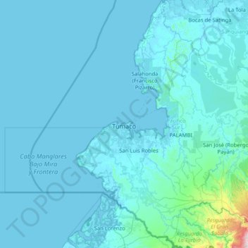
Name: Tumaco topographic map, elevation, terrain.
Location: Tumaco, Pacífico Sur, Nariño, Colombie (1.18750 -79.00785 2.44861 -78.25566)
Average elevation: 161 ft
Minimum elevation: -16 ft
Maximum elevation: 5,892 ft
Tumaco est situé dans le sud-ouest de la Colombie, à une altitude de 2 m. Bordée au nord par l'océan Pacifique et Francisco Pizarro, au sud par l'Équateur, à l'est par Roberto Payan et Barbacoas, et à l'ouest par l'océan Pacifique.
Other topographic maps
Click on a map to view its topography, its elevation and its terrain.
La Cordillera
La Cordillera, Nariño, RAP Pacífico, Colombie
Average elevation: 3,563 ft
San Fransico (6)
Colombie > Nariño > Contadero > Vereda Yaez
San Fransico (6), Vereda Yaez, Contadero, Exprovincia de Obando, Nariño, RAP Pacífico, 523087, Colombie
Average elevation: 9,199 ft
Perímetro Urbano Pasto
Perímetro Urbano Pasto, Pasto, Centro, Nariño, RAP Pacífico, Colombie
Average elevation: 8,780 ft
Providencia
Providencia, Los Abades, Nariño, RAP Pacífico, Colombie
Average elevation: 7,976 ft
La Florida
Colombie > Nariño > La Florida > La Florida
La Florida, Centro, Nariño, Colombie
Average elevation: 7,671 ft
Roberto Payán (San José)
Roberto Payán (San José), Telembí, Nariño, RAP Pacífico, Colombie
Average elevation: 180 ft
Cerro Las Minas
Cerro Las Minas, Buesaco, Nariño, Colombie
Average elevation: 6,345 ft