
Barnardsville topographic map
Interactive map
Click on the map to display elevation.
About this map
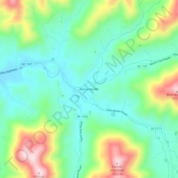
Name: Barnardsville topographic map, elevation, terrain.
Average elevation: 2,510 ft
Minimum elevation: 2,126 ft
Maximum elevation: 3,343 ft
Other topographic maps
Click on a map to view its topography, its elevation and its terrain.
Asheville
United States > North Carolina > Buncombe County
Asheville, Buncombe County, North Carolina, United States
Average elevation: 2,385 ft
Weaverville
United States > North Carolina > Buncombe County
Weaverville, Buncombe County, North Carolina, United States
Average elevation: 2,228 ft
Black Mountain
United States > North Carolina > Buncombe County
Black Mountain, Buncombe County, North Carolina, 28711, United States
Average elevation: 2,572 ft
Pisgah National Forest
United States > North Carolina > Buncombe County
Pisgah National Forest, Buncombe County, North Carolina, United States
Average elevation: 2,467 ft
Lake Powhatan
United States > North Carolina > Buncombe County
Lake Powhatan, Buncombe County, North Carolina, United States
Average elevation: 2,415 ft
Rainbow Mountain
United States > North Carolina > Buncombe County > Montreat
Rainbow Mountain, Montreat, Buncombe County, North Carolina, 28757, United States
Average elevation: 2,858 ft
Haw Creek
United States > North Carolina > Buncombe County > Asheville
Haw Creek, Asheville, Buncombe County, North Carolina, 28805, United States
Average elevation: 2,195 ft
Candler
United States > North Carolina > Buncombe County
Candler, Buncombe County, North Carolina, 28715, United States
Average elevation: 2,195 ft
Murphy Junction
United States > North Carolina > Buncombe County > Asheville
Murphy Junction, Asheville, Buncombe County, North Carolina, 28801, United States
Average elevation: 2,106 ft
Alexander Knob
United States > North Carolina > Buncombe County
Alexander Knob, Buncombe County, North Carolina, 28709, United States
Average elevation: 3,757 ft
Arden
United States > North Carolina > Buncombe County > Asheville
Arden, Asheville, Buncombe County, North Carolina, 28704, United States
Average elevation: 2,267 ft
Swannanoa
United States > North Carolina > Buncombe County
Swannanoa, Buncombe County, North Carolina, 28814, United States
Average elevation: 2,710 ft
Oteen
United States > North Carolina > Buncombe County > Asheville
Oteen, Asheville, Buncombe County, North Carolina, 28815, United States
Average elevation: 2,198 ft
Beaverdam
United States > North Carolina > Buncombe County
Beaverdam, Buncombe County, North Carolina, United States
Average elevation: 2,552 ft
Avery Creek
United States > North Carolina > Buncombe County
Avery Creek, Buncombe County, North Carolina, United States
Average elevation: 2,264 ft
Grovemont
United States > North Carolina > Buncombe County > Swannanoa
Grovemont, Swannanoa, Buncombe County, North Carolina, 28778, United States
Average elevation: 2,507 ft
Little Pisgah Camp Dam
United States > North Carolina > Buncombe County
Little Pisgah Camp Dam, Buncombe County, North Carolina, United States
Average elevation: 2,887 ft
Flat Creek
United States > North Carolina > Buncombe County
Flat Creek, Buncombe County, North Carolina, 28787, United States
Average elevation: 2,257 ft
Parkway Forest
United States > North Carolina > Buncombe County > Asheville
Parkway Forest, Asheville, Buncombe County, North Carolina, 28815, United States
Average elevation: 2,241 ft
Fairview
United States > North Carolina > Buncombe County
Fairview, Buncombe County, North Carolina, 28730, United States
Average elevation: 2,434 ft
Biltmore
United States > North Carolina > Buncombe County > Asheville
Biltmore, Asheville, Buncombe County, North Carolina, 28803, United States
Average elevation: 2,133 ft
Albemarle
United States > North Carolina > Buncombe County > Asheville
Albemarle, Asheville, Buncombe County, North Carolina, 28802, United States
Average elevation: 2,356 ft
Walker Falls
United States > North Carolina > Buncombe County
Walker Falls, Buncombe County, North Carolina, United States
Average elevation: 4,167 ft
Busbee
United States > North Carolina > Buncombe County > Asheville
Busbee, Asheville, Buncombe County, North Carolina, 28803, United States
Average elevation: 2,379 ft
Walkertown
United States > North Carolina > Buncombe County
Walkertown, Buncombe County, North Carolina, 28757, United States
Average elevation: 2,867 ft
Beech
United States > North Carolina > Buncombe County
Beech, Buncombe County, North Carolina, United States
Average elevation: 2,927 ft
Biltmore Forest
United States > North Carolina > Buncombe County
Biltmore Forest, Buncombe County, North Carolina, United States
Average elevation: 2,260 ft
Highland Gate
United States > North Carolina > Buncombe County > Asheville
Highland Gate, Asheville, Buncombe County, North Carolina, 28802, United States
Average elevation: 2,320 ft
Riceville
United States > North Carolina > Buncombe County
Riceville, Buncombe County, North Carolina, 28805, United States
Average elevation: 2,559 ft
Woolsey
United States > North Carolina > Buncombe County > Asheville
Woolsey, Asheville, Buncombe County, North Carolina, 28804, United States
Average elevation: 2,231 ft
Venable
United States > North Carolina > Buncombe County > Asheville
Venable, Asheville, Buncombe County, North Carolina, 28816, United States
Average elevation: 2,195 ft
Canto
United States > North Carolina > Buncombe County
Canto, Buncombe County, North Carolina, 28853, United States
Average elevation: 2,290 ft
Sandymush
United States > North Carolina > Buncombe County
Sandymush, Buncombe County, North Carolina, 28853, United States
Average elevation: 2,513 ft
Woodfin
United States > North Carolina > Buncombe County
Woodfin, Buncombe County, North Carolina, United States
Average elevation: 2,208 ft
Beaver Lake
United States > North Carolina > Buncombe County > Asheville > Grace
Beaver Lake, Grace, Asheville, Buncombe County, North Carolina, United States
Average elevation: 2,205 ft
Malvern Hills
United States > North Carolina > Buncombe County > Asheville
Malvern Hills, Asheville, Buncombe County, North Carolina, 28806, United States
Average elevation: 2,116 ft
Sayles Village
United States > North Carolina > Buncombe County > Asheville
Sayles Village, Asheville, Buncombe County, North Carolina, 28805, United States
Average elevation: 2,129 ft
Enka
United States > North Carolina > Buncombe County > Asheville
Enka, Asheville, Buncombe County, North Carolina, 28728, United States
Average elevation: 2,169 ft
Owltown
United States > North Carolina > Buncombe County > Owltown
Owltown, Buncombe County, North Carolina, United States
Average elevation: 2,566 ft
Enka Village
United States > North Carolina > Buncombe County > Asheville
Enka Village, Asheville, Buncombe County, North Carolina, 28728, United States
Average elevation: 2,198 ft
Ridgecrest
United States > North Carolina > Buncombe County > Ridgecrest
Ridgecrest, Buncombe County, North Carolina, 28770, United States
Average elevation: 2,871 ft
Boswell
United States > North Carolina > Buncombe County > Asheville > Boswell
Boswell, Asheville, Buncombe County, North Carolina, 28806, United States
Average elevation: 2,159 ft
Montreat
United States > North Carolina > Buncombe County
Montreat, Buncombe County, North Carolina, 28757, United States
Average elevation: 3,241 ft
Leicester
United States > North Carolina > Buncombe County
Leicester, Buncombe County, North Carolina, 28748, United States
Average elevation: 2,126 ft
Oak Forest
United States > North Carolina > Buncombe County > Asheville
Oak Forest, Asheville, Buncombe County, North Carolina, 28776, United States
Average elevation: 2,316 ft
Linwood Park
United States > North Carolina > Buncombe County > Asheville
Linwood Park, Asheville, Buncombe County, North Carolina, 28803, United States
Average elevation: 2,146 ft
South Slope
United States > North Carolina > Buncombe County > Asheville
South Slope, Asheville, Buncombe County, North Carolina, 28802, United States
Average elevation: 2,156 ft
Sulphur Springs
United States > North Carolina > Buncombe County > Asheville
Sulphur Springs, Asheville, Buncombe County, North Carolina, 28806, United States
Average elevation: 2,169 ft
Stony Fork
United States > North Carolina > Buncombe County
Stony Fork, Buncombe County, North Carolina, United States
Average elevation: 2,933 ft
Royal Pines
United States > North Carolina > Buncombe County > Asheville
Royal Pines, Asheville, Buncombe County, North Carolina, 28776, United States
Average elevation: 2,297 ft