Geolocate

Tipaimukh topographic map

Interactive map

Click on the map to display elevation.

About this map

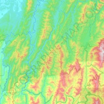
Name: Tipaimukh topographic map, elevation, terrain.

Location: Tipaimukh, Pherzawl, Manipur, 795143, India (24.04337 92.97071 24.57667 93.25024)

Average elevation: 1,585 ft

Minimum elevation: 52 ft

Maximum elevation: 6,512 ft

Other topographic maps

Click on a map to view its topography, its elevation and its terrain.

Thoubal River

India > Manipur > Saikul

Thoubal River, Saikul, Kangpokpi District, Manipur, India

Average elevation: 3,323 ft

Imphal

India > Manipur

Imphal, Imphal West, Manipur, 795001, India

Average elevation: 2,825 ft

Uchiwa

India > Manipur > Wangoi > Uchiwa

Uchiwa, Wangoi, Imphal West, Manipur, 795132, India

Average elevation: 2,530 ft

Lilong

India > Manipur > Lilong > Lilong

Lilong, Thoubal, Manipur, 795130, India

Average elevation: 2,552 ft

Chandel

India > Manipur

Chandel, Manipur, 795127, India

Average elevation: 3,169 ft

Chandel

India > Manipur

Chandel, Manipur, 795127, India

Average elevation: 2,822 ft