
Sevier County topographic map
Click on the map to display elevation.
Sevier County
Sevier County features a diverse and dramatic topography shaped by its proximity to the Great Smoky Mountains. This region is characterized by significant elevation changes, ranging from the low river valleys at about 850 feet near the French Broad River to the towering peaks of the Smokies, including Clingmans Dome, which rises to an impressive 6,643 feet. The southern part of the county is encompassed by the Great Smoky Mountains National Park, presenting rugged, mountainous terrain with steep ridges and deep valleys, while the northern areas transition into the gentler hills of the Ridge-and-Valley Appalachians. This striking contrast creates a vibrant ecosystem, attracting outdoor enthusiasts for activities like hiking and fishing in the numerous streams and lakes, including Douglas Lake formed by the Douglas Dam.
About this map
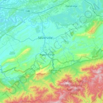
Name: Sevier County topographic map, elevation, terrain.
Location: Sevier County, East Tennessee, Tennessee, United States (35.56194 -83.79428 36.04312 -83.25153)
Average elevation: 1,965 ft
Minimum elevation: 823 ft
Maximum elevation: 6,631 ft
Tennessee trails, hiking, mountain biking, running and outdoor activities
Other topographic maps
Click on a map to view its topography, its elevation and its terrain.
Henderson Springs
United States > Tennessee > Sevier County > Pigeon Forge
Average elevation: 1,079 ft
Eastdale
United States > Tennessee > Hamilton County > Chattanooga > Ridgeside
Average elevation: 778 ft
Ridgedale
United States > Tennessee > Hamilton County > Chattanooga > Ridgeside
Average elevation: 768 ft
Barfield Crescent Park
United States > Tennessee > Rutherford County > Murfreesboro
Average elevation: 659 ft
Stonehenge Estates
United States > Tennessee > Williamson County > Brentwood
Average elevation: 840 ft
Cherokee Dam - Saddle Dam No. 1
United States > Tennessee > Jefferson County
Average elevation: 1,053 ft
Brainerd
United States > Tennessee > Hamilton County > Chattanooga > Ridgeside
Average elevation: 768 ft
Millersville City Park
United States > Tennessee > Robertson County > Millersville
Average elevation: 853 ft