
Make a donation
Gear up for your next adventure:
As an Amazon Associate, this site earns from qualifying purchases at no extra cost to you.
Charlotte Park topographic map
Click on the map to display elevation.
Make a donation
Gear up for your next adventure:
As an Amazon Associate, this site earns from qualifying purchases at no extra cost to you.
About this map
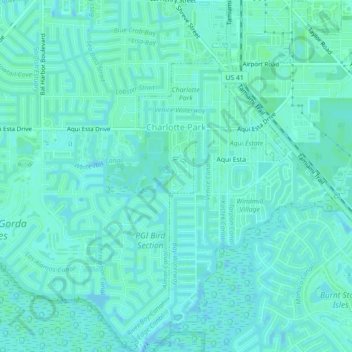
Name: Charlotte Park topographic map, elevation, terrain.
Location: Charlotte Park, Charlotte County, Florida, United States (26.88478 -82.05987 26.92425 -82.03268)
Average elevation: 10 ft
Minimum elevation: -3 ft
Maximum elevation: 20 ft
Charlotte County trails, hiking, mountain biking, running and outdoor activities
Make a donation
Gear up for your next adventure:
As an Amazon Associate, this site earns from qualifying purchases at no extra cost to you.
Other topographic maps
Click on a map to view its topography, its elevation and its terrain.
Port Charlotte
United States > Florida > Charlotte County
Port Charlotte is characterized by a predominantly flat and low-lying terrain, typical of Florida’s coastal landscape. The area features a network of waterways, including the Peace River and Charlotte Harbor, which provide ample opportunities for recreational activities like boating and fishing. Elevations…
Average elevation: 13 ft
Make a donation
Gear up for your next adventure:
As an Amazon Associate, this site earns from qualifying purchases at no extra cost to you.
Make a donation
Gear up for your next adventure:
As an Amazon Associate, this site earns from qualifying purchases at no extra cost to you.
South Gulf Cove Park
United States > Florida > Charlotte County > Port Charlotte
Average elevation: 10 ft
Peace River Botanical & Sculpture Gardens
United States > Florida > Charlotte County > Punta Gorda
Average elevation: 10 ft
Punta Gorda Isles
United States > Florida > Charlotte County > Punta Gorda > Punta Gorda Isles
Average elevation: 7 ft
Make a donation
Gear up for your next adventure:
As an Amazon Associate, this site earns from qualifying purchases at no extra cost to you.
Make a donation
Gear up for your next adventure:
As an Amazon Associate, this site earns from qualifying purchases at no extra cost to you.
Make a donation
Gear up for your next adventure:
As an Amazon Associate, this site earns from qualifying purchases at no extra cost to you.
Harbour Heights
United States > Florida > Charlotte County > Punta Gorda > Harbour Heights
Average elevation: 13 ft
Make a donation
Gear up for your next adventure:
As an Amazon Associate, this site earns from qualifying purchases at no extra cost to you.
Heritage Lake Park Community Development District
United States > Florida > Charlotte County
Average elevation: 23 ft
South Punta Gorda Heights
United States > Florida > Charlotte County > Punta Gorda
Average elevation: 26 ft
Make a donation
Gear up for your next adventure:
As an Amazon Associate, this site earns from qualifying purchases at no extra cost to you.
Make a donation
Gear up for your next adventure:
As an Amazon Associate, this site earns from qualifying purchases at no extra cost to you.
Peace River Preserve
United States > Florida > Charlotte County > Punta Gorda > Harbour Heights
Average elevation: 10 ft
South Gulf Cove Park
United States > Florida > Charlotte County > Port Charlotte
Average elevation: 10 ft
Make a donation
Gear up for your next adventure:
As an Amazon Associate, this site earns from qualifying purchases at no extra cost to you.
Make a donation
Gear up for your next adventure:
As an Amazon Associate, this site earns from qualifying purchases at no extra cost to you.
Placida
United States > Florida > Charlotte County
Placida is located at 26°49′55″N 82°15′54″W / 26.83194°N 82.265°W / 26.83194; -82.265Coordinates: 26°49′55″N 82°15′54″W / 26.83194°N 82.265°W / 26.83194; -82.265 (26.83194, -82.265). Placida has an elevation of 3 feet.
Average elevation: 3 ft
Make a donation
Gear up for your next adventure:
As an Amazon Associate, this site earns from qualifying purchases at no extra cost to you.
Gilcrest Park
United States > Florida > Charlotte County > Punta Gorda > Fishermens Village
Average elevation: 7 ft