Geolocate

Mount Olive topographic map

Click on the map to display elevation.

About this map

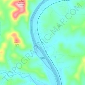
Name: Mount Olive topographic map, elevation, terrain.

Location: Mount Olive, Izard County, Arkansas, United States (35.98063 -92.11293 36.02063 -92.07293)

Average elevation: 479 ft

Minimum elevation: 302 ft

Maximum elevation: 1,073 ft

Izard County trails, hiking, mountain biking, running and outdoor activities

Other topographic maps

Click on a map to view its topography, its elevation and its terrain.

Mount Pleasant

United States > Arkansas > Izard County

Average elevation: 673 ft

Franklin

United States > Arkansas > Izard County

Average elevation: 666 ft

Guion

United States > Arkansas > Izard County

Average elevation: 466 ft

Pineville

United States > Arkansas > Izard County

Average elevation: 653 ft

Melbourne

United States > Arkansas > Izard County

Average elevation: 659 ft

Gear up for your next adventure:

🌡️Portable Weather Meter - Track weather conditions on the trail
🪶Camp Gear Gift Set - Perfect gift bundle for outdoor fans
🧥Men's Rain Shells - Premium waterproof and breathable jackets for mountain weather
🦶Carbon Trekking Poles - Reduce knee impact on steep descents with ultra-light poles
⛑️Personal Locator Beacon - Safety beacon for emergencies

As an Amazon Associate, this site earns from qualifying purchases at no extra cost to you.