Geolocate

Cleveland topographic map

Click on the map to display elevation.

About this map

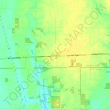
Name: Cleveland topographic map, elevation, terrain.

Location: Cleveland, Hancock County, Indiana, 46117, United States (39.77072 -85.66505 39.81072 -85.62505)

Average elevation: 958 ft

Minimum elevation: 915 ft

Maximum elevation: 988 ft

Hancock County trails, hiking, mountain biking, running and outdoor activities

Other topographic maps

Click on a map to view its topography, its elevation and its terrain.

Shirley

United States > Indiana > Hancock County

Average elevation: 1,024 ft

McCordsville

United States > Indiana > Hancock County

Average elevation: 850 ft

Greenfield

United States > Indiana > Hancock County

Average elevation: 892 ft

Gear up for your next adventure:

🚁Photography Drones - Capture stunning aerial views of landforms and topography
🛡️Bear Spray Outdoor - Protection in bear country hikes
🎒Trail Energy Bars - High‑calorie bars for hiking energy
🧯Emergency Survival Kit - All‑in‑one survival essentials for the backcountry
🪄Magnetic Compass - Accurate compass for navigation

As an Amazon Associate, this site earns from qualifying purchases at no extra cost to you.