Geolocate

Terry topographic map

Click on the map to display elevation.

About this map

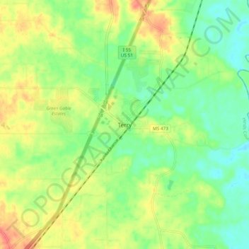
Name: Terry topographic map, elevation, terrain.

Location: Terry, Hinds County, Mississippi, 39170, United States (32.05626 -90.33426 32.13626 -90.25426)

Average elevation: 295 ft

Minimum elevation: 217 ft

Maximum elevation: 397 ft

Hinds County trails, hiking, mountain biking, running and outdoor activities

Other topographic maps

Click on a map to view its topography, its elevation and its terrain.

Utica

United States > Mississippi > Hinds County

Average elevation: 266 ft

Raymond

United States > Mississippi > Hinds County > Raymond

Average elevation: 289 ft

Bolton

United States > Mississippi > Hinds County > Bolton

Average elevation: 223 ft

Gear up for your next adventure:

📷Action Camera - Capture your outdoor adventures in HD
🔥Plasma Lighters - Windproof lighters that work in any weather condition
👟Men's Trail Runners - Lightweight footwear for fast-paced exploration and light hiking
📦Dry Bags Set - Waterproof storage for electronics and clothes
🛶Inflatable Kayak - Portable kayak for rivers, lakes, and expeditions

As an Amazon Associate, this site earns from qualifying purchases at no extra cost to you.