
Make a donation
Gear up for your next adventure:
As an Amazon Associate, this site earns from qualifying purchases at no extra cost to you.
lac Seul topographic map
Click on the map to display elevation.
Make a donation
Gear up for your next adventure:
As an Amazon Associate, this site earns from qualifying purchases at no extra cost to you.
lac Seul
Lac Seul is a large, crescent shaped reservoir in Kenora District, northwestern Ontario, Canada. It is approximately 241 km (150 mi) long. It has a maximum (regulated) depth of 47.2 m, with a surface elevation of 357 m above sea level. Its level is raised in the summer and then drawn down in the winter months to reach points of as low as 16 feet below the maximum level. It is the second largest body of water entirely within the province of Ontario (Lake Nipigon being first). The lake consists of open water bays, narrow channels, and islands. It is a relatively shallow lake with many rock shoals. This provides a good habitat for walleye (also known as "yellow pickerel") and northern pike as well as yellow perch. During the Lac Seul project of 1968-1972 no muskelunge were noted in the catches of research nets set over those years. Significant numbers of whitefish, tullibee, burbot and cisco were noted as well although they infrequently were noted in the sport fishery. Lac Seul is noted for offering some of the best fishing in Ontario.
Make a donation
Gear up for your next adventure:
As an Amazon Associate, this site earns from qualifying purchases at no extra cost to you.
About this map
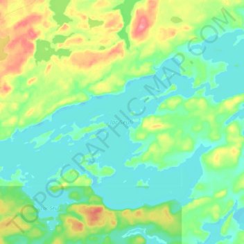
Name: lac Seul topographic map, elevation, terrain.
Average elevation: 1,227 ft
Minimum elevation: 1,152 ft
Maximum elevation: 1,414 ft
Make a donation
Gear up for your next adventure:
As an Amazon Associate, this site earns from qualifying purchases at no extra cost to you.
Other topographic maps
Click on a map to view its topography, its elevation and its terrain.
Carroll Lake
Canada > Ontario > Kenora District > Unorganized Kenora District
Average elevation: 1,109 ft
Wolf Island
Canada > Ontario > Kenora District > Unorganized Kenora District
Average elevation: 1,073 ft
Burditt Lake
Canada > Ontario > Kenora District > Unorganized Kenora District
Average elevation: 1,204 ft
Make a donation
Gear up for your next adventure:
As an Amazon Associate, this site earns from qualifying purchases at no extra cost to you.
Cardinal (Lac) Lake
Canada > Ontario > Kenora District > Unorganized Kenora District
Average elevation: 1,286 ft
Hudson Bay Lowlands
Canada > Ontario > Kenora District > Unorganized Kenora District
Average elevation: 56 ft
Make a donation
Gear up for your next adventure:
As an Amazon Associate, this site earns from qualifying purchases at no extra cost to you.
Canyon Lake
Canada > Ontario > Kenora District > Unorganized Kenora District
Average elevation: 1,329 ft
Granite Lake
Canada > Ontario > Kenora District > Unorganized Kenora District
Average elevation: 1,165 ft
Make a donation
Gear up for your next adventure:
As an Amazon Associate, this site earns from qualifying purchases at no extra cost to you.
Gordon Island
Canada > Ontario > Kenora District > Unorganized Kenora District
Average elevation: 1,145 ft
Twin Lake
Canada > Ontario > Kenora District > Unorganized Kenora District
Average elevation: 1,309 ft
Make a donation
Gear up for your next adventure:
As an Amazon Associate, this site earns from qualifying purchases at no extra cost to you.
Clear Lake
Canada > Ontario > Kenora District > Unorganized Kenora District
Average elevation: 1,204 ft
Shoal Lake
Canada > Ontario > Kenora District > Unorganized Kenora District
Average elevation: 1,066 ft
Grindstone Lake
Canada > Ontario > Kenora District > Unorganized Kenora District
Average elevation: 1,217 ft
Look Lake
Canada > Ontario > Kenora District > Unorganized Kenora District
Average elevation: 1,289 ft
Make a donation
Gear up for your next adventure:
As an Amazon Associate, this site earns from qualifying purchases at no extra cost to you.
Warwick Lake
Canada > Ontario > Kenora District > Unorganized Kenora District
Average elevation: 1,119 ft
Slate Islands
Canada > Ontario > Kenora District > Unorganized Kenora District
Average elevation: 1,056 ft
Make a donation
Gear up for your next adventure:
As an Amazon Associate, this site earns from qualifying purchases at no extra cost to you.
Mackey Island
Canada > Ontario > Kenora District > Unorganized Kenora District
Average elevation: 1,102 ft
Big Island Lake
Canada > Ontario > Kenora District > Unorganized Kenora District
Average elevation: 1,411 ft
Make a donation
Gear up for your next adventure:
As an Amazon Associate, this site earns from qualifying purchases at no extra cost to you.
Nine Mile Lake
Canada > Ontario > Kenora District > Unorganized Kenora District
Average elevation: 1,355 ft
Arpin Lake
Canada > Ontario > Kenora District > Unorganized Kenora District
Average elevation: 1,257 ft
Mills Lake
Canada > Ontario > Kenora District > Unorganized Kenora District
Average elevation: 1,247 ft
Betula Lake
Canada > Ontario > Kenora District > Unorganized Kenora District
Average elevation: 1,217 ft
Make a donation
Gear up for your next adventure:
As an Amazon Associate, this site earns from qualifying purchases at no extra cost to you.
Beauty Lake
Canada > Ontario > Kenora District > Unorganized Kenora District
Average elevation: 1,142 ft
Chisholm Island
Canada > Ontario > Kenora District > Unorganized Kenora District
Average elevation: 1,060 ft
Clearwater Bay
Canada > Ontario > Kenora District > Unorganized Kenora District
Average elevation: 1,096 ft
Boyne Lake
Canada > Ontario > Kenora District > Unorganized Kenora District
Average elevation: 1,184 ft
Make a donation
Gear up for your next adventure:
As an Amazon Associate, this site earns from qualifying purchases at no extra cost to you.
Muskeg River
Canada > Ontario > Kenora District > Unorganized Kenora District
Average elevation: 1,171 ft
Slate Falls
Canada > Ontario > Kenora District > Unorganized Kenora District
Average elevation: 1,263 ft
Muskeg River
Canada > Ontario > Kenora District > Unorganized Kenora District
Average elevation: 1,191 ft
Dingwall Island
Canada > Ontario > Kenora District > Unorganized Kenora District
Average elevation: 1,066 ft
Make a donation
Gear up for your next adventure:
As an Amazon Associate, this site earns from qualifying purchases at no extra cost to you.
Little Boulder Lake
Canada > Ontario > Kenora District > Unorganized Kenora District
Average elevation: 1,178 ft
Cameron Island
Canada > Ontario > Kenora District > Unorganized Kenora District
Average elevation: 1,109 ft
Make a donation
Gear up for your next adventure:
As an Amazon Associate, this site earns from qualifying purchases at no extra cost to you.