
Make a donation
Gear up for your next adventure:
As an Amazon Associate, this site earns from qualifying purchases at no extra cost to you.
Chisholm Island topographic map
Click on the map to display elevation.
Make a donation
Gear up for your next adventure:
As an Amazon Associate, this site earns from qualifying purchases at no extra cost to you.
About this map
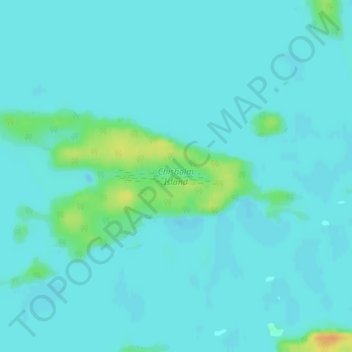
Name: Chisholm Island topographic map, elevation, terrain.
Average elevation: 1,060 ft
Minimum elevation: 1,043 ft
Maximum elevation: 1,148 ft
Make a donation
Gear up for your next adventure:
As an Amazon Associate, this site earns from qualifying purchases at no extra cost to you.
Other topographic maps
Click on a map to view its topography, its elevation and its terrain.
Clearwater Bay
Canada > Ontario > Kenora District > Unorganized Kenora District
Average elevation: 1,096 ft
Dogtooth Lake
Canada > Ontario > Kenora District > Unorganized Kenora District
Average elevation: 1,184 ft
MacDowell Lake
Canada > Ontario > Kenora District > Unorganized Kenora District
Average elevation: 1,266 ft
Rowdy Lake
Canada > Ontario > Kenora District > Unorganized Kenora District
Average elevation: 1,214 ft
Make a donation
Gear up for your next adventure:
As an Amazon Associate, this site earns from qualifying purchases at no extra cost to you.
Lake Charles
Canada > Ontario > Kenora District > Unorganized Kenora District
Average elevation: 1,135 ft
Fiddler Lake
Canada > Ontario > Kenora District > Unorganized Kenora District
Average elevation: 961 ft
Make a donation
Gear up for your next adventure:
As an Amazon Associate, this site earns from qualifying purchases at no extra cost to you.
Big Canon Lake
Canada > Ontario > Kenora District > Unorganized Kenora District
Average elevation: 1,191 ft
Star Lake
Canada > Ontario > Kenora District > Unorganized Kenora District
Average elevation: 1,253 ft
Hudson Bay Lowlands
Canada > Ontario > Kenora District > Unorganized Kenora District
Average elevation: 56 ft
Make a donation
Gear up for your next adventure:
As an Amazon Associate, this site earns from qualifying purchases at no extra cost to you.
Minnitaki Lake
Canada > Ontario > Kenora District > Unorganized Kenora District
Average elevation: 1,266 ft
Artery Lake
Canada > Ontario > Kenora District > Unorganized Kenora District
Average elevation: 1,096 ft
Maynard Lake
Canada > Ontario > Kenora District > Unorganized Kenora District
Average elevation: 1,106 ft
Canyon Lake
Canada > Ontario > Kenora District > Unorganized Kenora District
Average elevation: 1,329 ft
Make a donation
Gear up for your next adventure:
As an Amazon Associate, this site earns from qualifying purchases at no extra cost to you.
Kushog Lake
Canada > Ontario > Kenora District > Unorganized Kenora District
Average elevation: 1,329 ft
Confederation Lake
Canada > Ontario > Kenora District > Unorganized Kenora District
Average elevation: 1,358 ft
Fredart Lake
Canada > Ontario > Kenora District > Unorganized Kenora District
Average elevation: 1,342 ft
Make a donation
Gear up for your next adventure:
As an Amazon Associate, this site earns from qualifying purchases at no extra cost to you.
Two Island Lake
Canada > Ontario > Kenora District > Unorganized Kenora District
Average elevation: 1,184 ft
Affleck Lake
Canada > Ontario > Kenora District > Unorganized Kenora District
Average elevation: 1,381 ft
Spadina Lake
Canada > Ontario > Kenora District > Unorganized Kenora District
Average elevation: 1,234 ft
lac Seul
Canada > Ontario > Kenora District > Unorganized Kenora District
Lac Seul is a large, crescent shaped reservoir in Kenora District, northwestern Ontario, Canada. It is approximately 241 km (150 mi) long. It has a maximum (regulated) depth of 47.2 m, with a surface elevation of 357 m above sea level. Its level is raised in the summer and then drawn down in the winter months…
Average elevation: 1,227 ft
Make a donation
Gear up for your next adventure:
As an Amazon Associate, this site earns from qualifying purchases at no extra cost to you.
McIntosh Lake
Canada > Ontario > Kenora District > Unorganized Kenora District
Average elevation: 1,296 ft
Gordon Island
Canada > Ontario > Kenora District > Unorganized Kenora District
Average elevation: 1,145 ft
Make a donation
Gear up for your next adventure:
As an Amazon Associate, this site earns from qualifying purchases at no extra cost to you.
Blackstone Lake
Canada > Ontario > Kenora District > Unorganized Kenora District
Average elevation: 1,253 ft
Bass Lake
Canada > Ontario > Kenora District > Unorganized Kenora District
Average elevation: 1,270 ft
Make a donation
Gear up for your next adventure:
As an Amazon Associate, this site earns from qualifying purchases at no extra cost to you.
Winnipeg River
Canada > Ontario > Kenora District > Unorganized Kenora District
Average elevation: 1,040 ft
Shoal Lake
Canada > Ontario > Kenora District > Unorganized Kenora District
Average elevation: 1,066 ft
Cygnet Lake
Canada > Ontario > Kenora District > Unorganized Kenora District
Average elevation: 1,112 ft
Make a donation
Gear up for your next adventure:
As an Amazon Associate, this site earns from qualifying purchases at no extra cost to you.
Brock Lake
Canada > Ontario > Kenora District > Unorganized Kenora District
Average elevation: 1,020 ft
Make a donation
Gear up for your next adventure:
As an Amazon Associate, this site earns from qualifying purchases at no extra cost to you.
Mackey Island
Canada > Ontario > Kenora District > Unorganized Kenora District
Average elevation: 1,102 ft
Betula Lake
Canada > Ontario > Kenora District > Unorganized Kenora District
Average elevation: 1,217 ft
Stormy Lake
Canada > Ontario > Kenora District > Unorganized Kenora District
Average elevation: 1,358 ft
Make a donation
Gear up for your next adventure:
As an Amazon Associate, this site earns from qualifying purchases at no extra cost to you.
Whitefish Lake
Canada > Ontario > Kenora District > Unorganized Kenora District
Average elevation: 1,247 ft
Slate Falls
Canada > Ontario > Kenora District > Unorganized Kenora District
Average elevation: 1,263 ft
Wabaskang Lake
Canada > Ontario > Kenora District > Unorganized Kenora District
Average elevation: 1,230 ft
Eagle Lake
Canada > Ontario > Kenora District > Unorganized Kenora District
Average elevation: 1,243 ft
Make a donation
Gear up for your next adventure:
As an Amazon Associate, this site earns from qualifying purchases at no extra cost to you.
Kukukus Lake
Canada > Ontario > Kenora District > Unorganized Kenora District
Average elevation: 1,329 ft
Minnitaki Lake
Canada > Ontario > Kenora District > Unorganized Kenora District
Average elevation: 1,266 ft
Cluster Lakes
Canada > Ontario > Kenora District > Unorganized Kenora District
Average elevation: 1,453 ft
Make a donation
Gear up for your next adventure:
As an Amazon Associate, this site earns from qualifying purchases at no extra cost to you.
Antenna Lake
Canada > Ontario > Kenora District > Unorganized Kenora District
Average elevation: 1,289 ft
Swan Lake
Canada > Ontario > Kenora District > Unorganized Kenora District
Average elevation: 1,060 ft
Cameron Island
Canada > Ontario > Kenora District > Unorganized Kenora District
Average elevation: 1,109 ft
Make a donation
Gear up for your next adventure:
As an Amazon Associate, this site earns from qualifying purchases at no extra cost to you.