
Cumberland topographic map
Interactive map
Click on the map to display elevation.
About this map
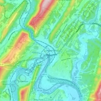
Name: Cumberland topographic map, elevation, terrain.
Location: Cumberland, Allegany County, Maryland, 21502, United States (39.61925 -78.81253 39.68598 -78.71091)
Average elevation: 866 ft
Minimum elevation: 571 ft
Maximum elevation: 1,827 ft
Other topographic maps
Click on a map to view its topography, its elevation and its terrain.
Frostburg
United States > Maryland > Allegany County
Frostburg, Allegany County, Maryland, 21532, United States
Average elevation: 2,034 ft
Bel Air
United States > Maryland > Allegany County
Bel Air, Allegany County, Maryland, United States
Average elevation: 863 ft
Oldtown
United States > Maryland > Allegany County
Oldtown, Allegany County, Maryland, 26722, United States
Average elevation: 636 ft
Cresaptown
United States > Maryland > Allegany County
Cresaptown, Allegany County, Maryland, United States
Average elevation: 846 ft
Green Ridge State Forest
United States > Maryland > Allegany County
Green Ridge State Forest, Allegany County, Maryland, United States
Average elevation: 968 ft
Moscow
United States > Maryland > Allegany County
Moscow, Allegany County, Maryland, 21521, United States
Average elevation: 1,785 ft
Westernport
United States > Maryland > Allegany County
Westernport, Allegany County, Maryland, United States
Average elevation: 1,312 ft
Franklin
United States > Maryland > Allegany County
Franklin, Allegany County, Maryland, 26750, United States
Average elevation: 1,486 ft
McCoole
United States > Maryland > Allegany County
McCoole, Allegany County, Maryland, 26726, United States
Average elevation: 945 ft
McKenzie
United States > Maryland > Allegany County
McKenzie, Allegany County, Maryland, United States
Average elevation: 915 ft
Carlos
United States > Maryland > Allegany County
Carlos, Allegany County, Maryland, 21543, United States
Average elevation: 2,083 ft
Eckhart Mines
United States > Maryland > Allegany County
Eckhart Mines, Allegany County, Maryland, 21528, United States
Average elevation: 1,880 ft
Midlothian
United States > Maryland > Allegany County
Midlothian, Allegany County, Maryland, 21543, United States
Average elevation: 2,093 ft
Pleasant Grove
United States > Maryland > Allegany County
Pleasant Grove, Allegany County, Maryland, United States
Average elevation: 1,047 ft
Pinto
United States > Maryland > Allegany County > Bel Air
Pinto, Bel Air, Allegany County, Maryland, United States
Average elevation: 810 ft
Bier
United States > Maryland > Allegany County
Bier, Allegany County, Maryland, United States
Average elevation: 938 ft
Bowmans Addition
United States > Maryland > Allegany County
Bowmans Addition, Allegany County, Maryland, 21529, United States
Average elevation: 1,132 ft
Dawson
United States > Maryland > Allegany County
Dawson, Allegany County, Maryland, 21557, United States
Average elevation: 1,063 ft
Ocean
United States > Maryland > Allegany County
Ocean, Allegany County, Maryland, 21542, United States
Average elevation: 1,946 ft
Spring Gap
United States > Maryland > Allegany County
Spring Gap, Allegany County, Maryland, 21560, United States
Average elevation: 715 ft
Barton
United States > Maryland > Allegany County
Barton, Allegany County, Maryland, United States
Average elevation: 1,585 ft
Luke
United States > Maryland > Allegany County
Luke, Allegany County, Maryland, 21540, United States
Average elevation: 1,316 ft
Barrelville
United States > Maryland > Allegany County
Barrelville, Allegany County, Maryland, 15564, United States
Average elevation: 1,437 ft
Ellerslie
United States > Maryland > Allegany County
Ellerslie, Allegany County, Maryland, 21529, United States
Average elevation: 1,079 ft
Detmold
United States > Maryland > Allegany County
Detmold, Allegany County, Maryland, 21539, United States
Average elevation: 1,893 ft
Klondike
United States > Maryland > Allegany County
Klondike, Allegany County, Maryland, 21542, United States
Average elevation: 2,060 ft
Lavale Community Park
United States > Maryland > Allegany County > Allegany Grove
Lavale Community Park, Allegany Grove, Allegany County, Maryland, United States
Average elevation: 1,161 ft
Nikep
United States > Maryland > Allegany County
Nikep, Allegany County, Maryland, 21521, United States
Average elevation: 1,841 ft
Shaft
United States > Maryland > Allegany County > Borden Shaft > Braddock Estates
Shaft, Braddock Estates, Borden Shaft, Allegany County, Maryland, United States
Average elevation: 1,929 ft
Vale Summit
United States > Maryland > Allegany County
Vale Summit, Allegany County, Maryland, 21528, United States
Average elevation: 2,149 ft
Amcelle
United States > Maryland > Allegany County > Potomac Park
Amcelle, Potomac Park, Allegany County, Maryland, 26753, United States
Average elevation: 955 ft
Zihlman
United States > Maryland > Allegany County
Zihlman, Allegany County, Maryland, 21528, United States
Average elevation: 1,936 ft
North Branch
United States > Maryland > Allegany County
North Branch, Allegany County, Maryland, 26767, United States
Average elevation: 791 ft
Little Orleans
United States > Maryland > Allegany County
Little Orleans, Allegany County, Maryland, 21766, United States
Average elevation: 633 ft
Midland
United States > Maryland > Allegany County
Midland, Allegany County, Maryland, 21542, United States
Average elevation: 1,870 ft
Bowling Green
United States > Maryland > Allegany County
Bowling Green, Allegany County, Maryland, 21502, United States
Average elevation: 984 ft
Clarysville
United States > Maryland > Allegany County
Clarysville, Allegany County, Maryland, 21528, United States
Average elevation: 1,946 ft
Danville
United States > Maryland > Allegany County
Danville, Allegany County, Maryland, 21557, United States
Average elevation: 1,168 ft
Corriganville
United States > Maryland > Allegany County
Corriganville, Allegany County, Maryland, 21524, United States
Average elevation: 1,073 ft
Gilmore
United States > Maryland > Allegany County
Gilmore, Allegany County, Maryland, 21542, United States
Average elevation: 1,972 ft
Grahamtown
United States > Maryland > Allegany County
Grahamtown, Allegany County, Maryland, 21532, United States
Average elevation: 1,972 ft
National
United States > Maryland > Allegany County
National, Allegany County, Maryland, 21542, United States
Average elevation: 1,949 ft
Potomac Park
United States > Maryland > Allegany County
Potomac Park, Allegany County, Maryland, 26753, United States
Average elevation: 948 ft
Woodland
United States > Maryland > Allegany County
Woodland, Allegany County, Maryland, 21542, United States
Average elevation: 1,962 ft
Lavale District Park
United States > Maryland > Allegany County > La Vale
Lavale District Park, La Vale, Allegany County, Maryland, United States
Average elevation: 1,063 ft
County Fairgrounds
United States > Maryland > Allegany County > Potomac Park > Cedar Cliff
County Fairgrounds, Cedar Cliff, Potomac Park, Allegany County, Maryland, United States
Average elevation: 899 ft
Lonaconing
United States > Maryland > Allegany County
Lonaconing, Allegany County, Maryland, United States
Average elevation: 1,837 ft
Mexico
United States > Maryland > Allegany County
Mexico, Allegany County, Maryland, 26767, United States
Average elevation: 735 ft
Oldtown
United States > Maryland > Allegany County > Oldtown
Oldtown, Allegany County, Maryland, United States
Average elevation: 607 ft
Pleasant Grove
United States > Maryland > Allegany County > Pleasant Grove
Pleasant Grove, Allegany County, Maryland, United States
Average elevation: 984 ft