
楚鲁松杰乡 topographic map
Interactive map
Click on the map to display elevation.
About this map
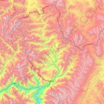
Name: 楚鲁松杰乡 topographic map, elevation, terrain.
Location: 楚鲁松杰乡, 札达县, 阿里地区, 西藏自治区, 中国 (31.95376 78.39232 32.69575 79.29193)
Average elevation: 16,473 ft
Minimum elevation: 9,836 ft
Maximum elevation: 21,670 ft
楚鲁松杰乡地处札达县西北部的喜马拉雅山西缘,平均海拔4100米,距札达县城托林镇320公里,距离曲松乡政府所在地曲木底110公里。边境线长92公里,有通外山口3个。楚鲁松杰乡北面与印度拉达克的交界处,有楚木惹、斯诺乌山争议区。 楚鲁松杰乡西南面与印度喜马偕尔邦有巨哇(英语:Gue_(Lahul_and_Spiti))、曲惹(英语:Kaurik)、江阿尔(Sumdo)争议区,皆为中国主张领土,现由印度实际控制,现今由喜马偕尔邦拉豪爾和斯皮提縣管辖。
Other topographic maps
Click on a map to view its topography, its elevation and its terrain.