
Make a donation
Gear up for your next adventure:
As an Amazon Associate, this site earns from qualifying purchases at no extra cost to you.
Kakamega County topographic map
Click on the map to display elevation.
Make a donation
Gear up for your next adventure:
As an Amazon Associate, this site earns from qualifying purchases at no extra cost to you.
Kakamega County
Kakamega County has an altitude ranging from 1,240 metres to 2,000 metres above sea level. The southern part of the county is hilly and made of granites which raises it 1950m above sea level. The Nandi Escarpment is a key feature on the eastern border of the county with steep cliffs rising from 1700m to 2000m. The county is also endowed with a number of hills like Misango, Imanga, Eregi, Butieri, Sikhokhochole, Mawe Tatu, Lirhanda, Kiming’ini hills among others.
Make a donation
Gear up for your next adventure:
As an Amazon Associate, this site earns from qualifying purchases at no extra cost to you.
About this map
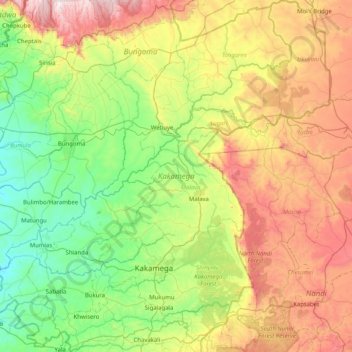
Name: Kakamega County topographic map, elevation, terrain.
Location: Kakamega County, Western, Kenya (0.08911 34.34632 0.90044 35.15610)
Average elevation: 5,446 ft
Minimum elevation: 4,032 ft
Maximum elevation: 8,228 ft
Make a donation
Gear up for your next adventure:
As an Amazon Associate, this site earns from qualifying purchases at no extra cost to you.
Other topographic maps
Click on a map to view its topography, its elevation and its terrain.
Make a donation
Gear up for your next adventure:
As an Amazon Associate, this site earns from qualifying purchases at no extra cost to you.
Sleeping Warrior (Delamare's Nose)
Kenya > Nakuru > Gilgil > Mbaruk/Eburu ward > Ututu
Average elevation: 6,070 ft
Make a donation
Gear up for your next adventure:
As an Amazon Associate, this site earns from qualifying purchases at no extra cost to you.
Make a donation
Gear up for your next adventure:
As an Amazon Associate, this site earns from qualifying purchases at no extra cost to you.
Mombasa
Kenya > Mombasa County > Mvita
Being a coastal town, Mombasa is characterised by a flat topography. The town of Mombasa is centred on Mombasa Island, but extends to the mainland. The island is separated from the mainland by two creeks, Port Reitz in the south and Tudor Creek in the north.
Average elevation: 105 ft
Make a donation
Gear up for your next adventure:
As an Amazon Associate, this site earns from qualifying purchases at no extra cost to you.
Make a donation
Gear up for your next adventure:
As an Amazon Associate, this site earns from qualifying purchases at no extra cost to you.
Make a donation
Gear up for your next adventure:
As an Amazon Associate, this site earns from qualifying purchases at no extra cost to you.
Nakuru
Kenya > Nakuru > Nakuru West
On 3 June 2021, Nakuru was officially endorsed for city status after the Kenyan Senate voted for its elevation from a municipality. Following the approval of the Senate of Kenya in June, the President of the Republic of Kenya gave a city charter for official transformation of Nakuru to a city status in…
Average elevation: 6,302 ft