
Badwater topographic map
Interactive map
Click on the map to display elevation.
About this map
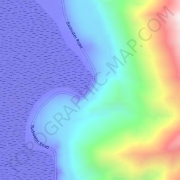
Name: Badwater topographic map, elevation, terrain.
Location: Badwater, Inyo County, California, United States (36.21967 -116.77699 36.23967 -116.75699)
Average elevation: 528 ft
Minimum elevation: -276 ft
Maximum elevation: 3,091 ft
Other topographic maps
Click on a map to view its topography, its elevation and its terrain.
Bishop
United States > California > Inyo County
Bishop, Inyo County, California, United States
Average elevation: 4,150 ft
Trona
United States > California > Inyo County
Trona, Inyo County, California, United States
Average elevation: 1,867 ft
Beveridge
United States > California > Inyo County
Beveridge, Inyo County, California, United States
Average elevation: 6,801 ft
Tecopa
United States > California > Inyo County
Tecopa, Inyo County, California, United States
Average elevation: 1,437 ft
Round Valley
United States > California > Inyo County
Round Valley, Inyo County, California, United States
Average elevation: 4,892 ft
Deep Springs
United States > California > Inyo County
Deep Springs, Inyo County, California, United States
Average elevation: 5,348 ft
Pearsonville
United States > California > Inyo County
Pearsonville, Inyo County, California, United States
Average elevation: 2,612 ft
Shoshone
United States > California > Inyo County
Shoshone, Inyo County, California, 92384, United States
Average elevation: 1,699 ft
Owenyo
United States > California > Inyo County
Owenyo, Inyo County, California, United States
Average elevation: 3,842 ft
Park Village
United States > California > Inyo County
Park Village, Inyo County, California, United States
Average elevation: 210 ft
Reward
United States > California > Inyo County
Reward, Inyo County, California, United States
Average elevation: 4,475 ft
Darwin
United States > California > Inyo County
Darwin, Inyo County, California, 93522, United States
Average elevation: 4,869 ft
Charleston View
United States > California > Inyo County
Charleston View, Inyo County, California, United States
Average elevation: 2,631 ft
Cartago
United States > California > Inyo County
Cartago, Inyo County, California, United States
Average elevation: 3,780 ft
Death Valley Junction
United States > California > Inyo County
Death Valley Junction, Inyo County, California, United States
Average elevation: 2,057 ft
Mock
United States > California > Inyo County
Mock, Inyo County, California, United States
Average elevation: 3,845 ft
Harrisburg
United States > California > Inyo County
Harrisburg, Inyo County, California, United States
Average elevation: 5,233 ft
Swansea
United States > California > Inyo County
Swansea, Inyo County, California, 93530, United States
Average elevation: 3,930 ft
Lone Pine
United States > California > Inyo County
Lone Pine, Inyo County, California, 93545, United States
Average elevation: 4,259 ft
Big Pine
United States > California > Inyo County
Big Pine, Inyo County, California, 92513, United States
Average elevation: 4,042 ft
Mount Whitney
United States > California > Inyo County
Mount Whitney, Inyo County, California, United States
Average elevation: 12,805 ft
Ryan
United States > California > Inyo County
Ryan, Inyo County, California, United States
Average elevation: 3,173 ft
Homewood Canyon-Valley Wells
United States > California > Inyo County
Homewood Canyon-Valley Wells, Inyo County, California, United States
Average elevation: 3,100 ft
Chicago Valley
United States > California > Inyo County
Chicago Valley, Inyo County, California, United States
Average elevation: 2,169 ft
Fish Springs
United States > California > Inyo County
Fish Springs, Inyo County, California, United States
Average elevation: 4,065 ft
Gem Lakes
United States > California > Inyo County
Gem Lakes, Inyo County, California, United States
Average elevation: 11,421 ft
Independence
United States > California > Inyo County
Independence, Inyo County, California, 93526, United States
Average elevation: 3,970 ft
Kearsarge
United States > California > Inyo County
Kearsarge, Inyo County, California, United States
Average elevation: 3,802 ft
Aspendell
United States > California > Inyo County
Aspendell, Inyo County, California, United States
Average elevation: 9,288 ft
Upper Lamarck Lake
United States > California > Inyo County
Upper Lamarck Lake, Inyo County, California, United States
Average elevation: 11,342 ft
Mount Perry
United States > California > Inyo County
Mount Perry, Inyo County, California, United States
Average elevation: 4,334 ft
Mount LeConte
United States > California > Inyo County
Mount LeConte, Inyo County, CAL Fire Southern Region, California, United States
Average elevation: 12,431 ft
Little Lake
United States > California > Inyo County
Little Lake, Inyo County, California, United States
Average elevation: 3,563 ft
West Bishop
United States > California > Inyo County
West Bishop, Inyo County, California, United States
Average elevation: 4,859 ft
Wildrose Peak
United States > California > Inyo County
Wildrose Peak, Inyo County, California, United States
Average elevation: 7,881 ft
Owens Valley
United States > California > Inyo County
Owens Valley, Inyo County, CAL Fire Southern Region, California, United States
Average elevation: 6,857 ft
Sandy Valley
United States > California > Inyo County
Sandy Valley, Inyo County, California, United States
Average elevation: 2,648 ft
Death Valley Playa
United States > California > Inyo County
Death Valley Playa, Inyo County, California, United States
Average elevation: 2,881 ft
Olancha
United States > California > Inyo County
Olancha, Inyo County, California, 93549, United States
Average elevation: 3,937 ft
Tin Mountain
United States > California > Inyo County
Tin Mountain, Inyo County, California, United States
Average elevation: 7,835 ft
Palisade Glacier
United States > California > Inyo County
Palisade Glacier, Inyo County, California, United States
Average elevation: 12,595 ft
Alabama Hills
United States > California > Inyo County > Lone Pine
Alabama Hills, Lone Pine, Inyo County, California, 93545, United States
Average elevation: 4,426 ft
Big Pine
United States > California > Inyo County > Big Pine
Big Pine, Inyo County, California, 92513, United States
Average elevation: 4,029 ft
Big Pine Creek
United States > California > Inyo County > Big Pine
Big Pine Creek, Big Pine, Inyo County, California, 92513, United States
Average elevation: 3,970 ft
Racetrack Playa
United States > California > Inyo County
Racetrack Playa, Inyo County, California, United States
Average elevation: 3,999 ft
Ancient Bristlecone Pine Forest
United States > California > Inyo County
Ancient Bristlecone Pine Forest, Inyo County, California, United States
Average elevation: 9,337 ft
Stovepipe Wells
United States > California > Inyo County
Stovepipe Wells, Inyo County, California, United States
Average elevation: 69 ft
Towne Benchmark
United States > California > Inyo County
Towne Benchmark, Inyo County, California, United States
Average elevation: 6,342 ft
Mount Haeckel
United States > California > Inyo County
Mount Haeckel, Inyo County, California, United States
Average elevation: 12,224 ft
Dirty Socks Hot Spring
United States > California > Inyo County > Olancha
Dirty Socks Hot Spring, CA 190, Olancha, Inyo County, California, 93549, United States
Average elevation: 3,625 ft