
Make a donation
Gear up for your next adventure:
As an Amazon Associate, this site earns from qualifying purchases at no extra cost to you.
Montan - Montagna topographic map
Click on the map to display elevation.
Make a donation
Gear up for your next adventure:
As an Amazon Associate, this site earns from qualifying purchases at no extra cost to you.
About this map
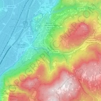
Name: Montan - Montagna topographic map, elevation, terrain.
Average elevation: 2,858 ft
Minimum elevation: 666 ft
Maximum elevation: 5,883 ft
Make a donation
Gear up for your next adventure:
As an Amazon Associate, this site earns from qualifying purchases at no extra cost to you.
Other topographic maps
Click on a map to view its topography, its elevation and its terrain.
Compatsch
Italy > Trentino-Alto Adige/Südtirol > South Tyrol > Kastelruth - Castelrotto
Average elevation: 6,099 ft
Neuwies - Pratonuovo
Italy > Trentino-Alto Adige/Südtirol > South Tyrol > Stilfs - Stelvio > Trafoi
Average elevation: 6,850 ft
Rentsch
Italy > Trentino-Alto Adige/Südtirol > South Tyrol > Bolzano - Bozen
Average elevation: 1,808 ft
Similaun
Italy > Trentino-Alto Adige/Südtirol > South Tyrol > Schnals - Senales
Average elevation: 10,387 ft
Make a donation
Gear up for your next adventure:
As an Amazon Associate, this site earns from qualifying purchases at no extra cost to you.
Plan de Gralba
Italy > Trentino-Alto Adige/Südtirol > South Tyrol > Sëlva - Wolkenstein - Selva di Val Gardena
Average elevation: 6,873 ft
Kurzras - Maso Corto
Italy > Trentino-Alto Adige/Südtirol > South Tyrol > Schnals - Senales
Average elevation: 8,061 ft
Make a donation
Gear up for your next adventure:
As an Amazon Associate, this site earns from qualifying purchases at no extra cost to you.
St. Josef am See - San Giuseppe al Lago
Italy > Trentino-Alto Adige/Südtirol > South Tyrol > Kaltern an der Weinstraße - Caldaro sulla Strada del Vino
Average elevation: 1,535 ft
Kohl
Italy > Trentino-Alto Adige/Südtirol > South Tyrol > Sarntal - Sarentino
Average elevation: 5,213 ft
Piz dles Döes Forceles
Italy > Trentino-Alto Adige/Südtirol > South Tyrol > Badia - Abtei
Average elevation: 8,146 ft
Seis am Schlern - Siusi allo Sciliar
Italy > Trentino-Alto Adige/Südtirol > South Tyrol > Kastelruth - Castelrotto
Average elevation: 3,973 ft
Make a donation
Gear up for your next adventure:
As an Amazon Associate, this site earns from qualifying purchases at no extra cost to you.
Ciaminades
Italy > Trentino-Alto Adige/Südtirol > South Tyrol > Badia - Abtei
Average elevation: 5,361 ft
St. Jakob - San Giacomo
Italy > Trentino-Alto Adige/Südtirol > South Tyrol > Laives - Leifers
Average elevation: 1,421 ft
Rüdeferia
Italy > Trentino-Alto Adige/Südtirol > South Tyrol > Badia - Abtei
Average elevation: 5,709 ft
St. Martin - San Martino in Casies
Italy > Trentino-Alto Adige/Südtirol > South Tyrol > Gsies - Valle di Casies > St. Martin - San Martino in Casies
Average elevation: 5,489 ft
Make a donation
Gear up for your next adventure:
As an Amazon Associate, this site earns from qualifying purchases at no extra cost to you.
Passo dello Stelvio
Italy > Trentino-Alto Adige/Südtirol > South Tyrol > Stilfs - Stelvio
The Stelvio Pass (Italian: Passo dello Stelvio [passo ˈdello ˈstɛlvjo], Giogo dello Stelvio [dʒɔgo ˈdello ˈstɛlvjo]; German: Stilfser Joch; [ˈʃtɪlfsɐ jɔx]) is a mountain pass in northern Italy bordering Switzerland at an elevation of 2,757 m (9,045 ft) above sea level. It is the highest paved…
Average elevation: 8,937 ft
Klockerkarkopf - Vetta d'Italia
Italy > Trentino-Alto Adige/Südtirol > South Tyrol > Predoi
Average elevation: 8,271 ft
Fleins - Lines
Italy > Trentino-Alto Adige/Südtirol > South Tyrol > Freienfeld - Campo di Trens > Mauls - Mules
Average elevation: 4,485 ft
Make a donation
Gear up for your next adventure:
As an Amazon Associate, this site earns from qualifying purchases at no extra cost to you.
Weißkugel - Palla Bianca
Italy > Trentino-Alto Adige/Südtirol > South Tyrol > Graun - Curon Venosta
Average elevation: 10,531 ft
Kampill - Campiglio
Italy > Trentino-Alto Adige/Südtirol > South Tyrol > Bolzano - Bozen > Rentsch - Rencio > Kampill - Campiglio
Average elevation: 1,909 ft
Gornerberg (Henne)
Italy > Trentino-Alto Adige/Südtirol > South Tyrol > Mühlwald - Selva dei Molini
Average elevation: 6,982 ft
Make a donation
Gear up for your next adventure:
As an Amazon Associate, this site earns from qualifying purchases at no extra cost to you.
Nauders - San Benedetto
Italy > Trentino-Alto Adige/Südtirol > South Tyrol
Average elevation: 3,268 ft
Prad am Stilfser Joch - Prato allo Stelvio
Italy > Trentino-Alto Adige/Südtirol > South Tyrol > Prad am Stilfserjoch - Prato allo Stelvio
Average elevation: 3,537 ft