
西坑 topographic map
Interactive map
Click on the map to display elevation.
About this map
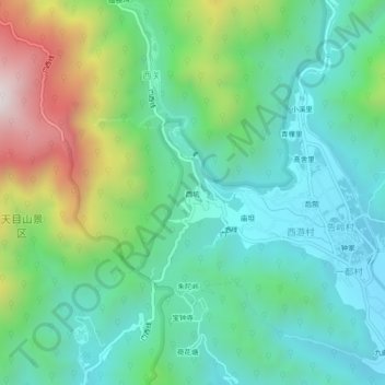
Name: 西坑 topographic map, elevation, terrain.
Location: 西坑, 天目山镇, 临安区, 杭州市, 浙江省, 中国 (30.31814 119.43589 30.35814 119.47589)
Average elevation: 1,837 ft
Minimum elevation: 879 ft
Maximum elevation: 4,272 ft
Other topographic maps
Click on a map to view its topography, its elevation and its terrain.