Geolocate

Preston topographic map

Click on the map to display elevation.

About this map

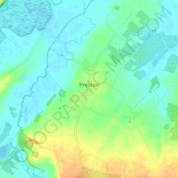
Name: Preston topographic map, elevation, terrain.

Location: Preston, Dover, Kent, England, United Kingdom (51.28373 1.20308 51.32159 1.26206)

Average elevation: 33 ft

Minimum elevation: -7 ft

Maximum elevation: 102 ft

Other topographic maps

Click on a map to view its topography, its elevation and its terrain.

Kearsney

United Kingdom > England > Kent > Dover

Average elevation: 308 ft

Elmstone

United Kingdom > England > Kent > Dover > Preston

Average elevation: 43 ft

Dover Castle

United Kingdom > England > Kent > Dover

Average elevation: 154 ft

Sandwich Bay

United Kingdom > England > Kent > Dover

Average elevation: 3 ft

Westmarsh

United Kingdom > England > Kent > Dover > Ash

Average elevation: 26 ft

Ham

United Kingdom > England > Kent > Dover

Average elevation: 52 ft

Shatterling

United Kingdom > England > Kent > Dover > Staple

Average elevation: 59 ft

Church Hougham

United Kingdom > England > Kent > Dover

Average elevation: 292 ft

Wootton

United Kingdom > England > Kent > Dover

Average elevation: 390 ft

Martin

United Kingdom > England > Kent > Dover

Average elevation: 230 ft

Ringwould

United Kingdom > England > Kent > Dover

Average elevation: 148 ft

Waldershare

United Kingdom > England > Kent > Dover > Tilmanstone

Average elevation: 292 ft

River Stour

United Kingdom > England > Kent > Dover > Ash

Average elevation: 10 ft

Hacklinge

United Kingdom > England > Kent > Dover > Worth

Average elevation: 33 ft

Lower Eythorne

United Kingdom > England > Kent > Dover > Eythorne

Average elevation: 246 ft

Wolverton

United Kingdom > England > Kent > Dover > Alkham > Wolverton

Average elevation: 354 ft

South Alkham

United Kingdom > England > Kent > Dover > Alkham > South Alkham

Average elevation: 404 ft

Coldred

United Kingdom > England > Kent > Dover > Shepherdswell > Coldred

Average elevation: 348 ft

Barnsole

United Kingdom > England > Kent > Dover > Staple

Average elevation: 79 ft

Richborough

United Kingdom > England > Kent > Dover

Average elevation: 13 ft

Green Lane Hill

United Kingdom > England > Kent > Dover > Whitfield

Average elevation: 305 ft

Gear up for your next adventure:

🔦LED Headlamp - Bright and durable LED headlamp for night navigation
🚁Photography Drones - Capture stunning aerial views of landforms and topography
🪑Portable Camp Table - Compact table for campsite meals
📌Outdoor GPS Map App - Apps and devices for digital topographic navigation
🧭GPS Watch Accessories - Bands and chargers for GPS watches

As an Amazon Associate, this site earns from qualifying purchases at no extra cost to you.