Geolocate

Echo topographic map

Click on the map to display elevation.

About this map

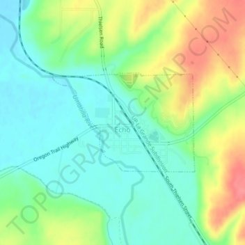
Name: Echo topographic map, elevation, terrain.

Location: Echo, Umatilla County, Oregon, United States (45.73725 -119.20601 45.74815 -119.18341)

Average elevation: 696 ft

Minimum elevation: 610 ft

Maximum elevation: 846 ft

Umatilla County trails, hiking, mountain biking, running and outdoor activities

Other topographic maps

Click on a map to view its topography, its elevation and its terrain.

Wallula Gap

United States > Oregon > Umatilla County

Average elevation: 1,027 ft

Ferndale

United States > Oregon > Umatilla County

Average elevation: 840 ft

Ward Butte

United States > Oregon > Umatilla County

Average elevation: 784 ft

Carney Butte

United States > Oregon > Umatilla County

Average elevation: 4,393 ft

Gear up for your next adventure:

🧢Outdoor Hiking Hat - Sun protection hat for outdoor explorers
💧Water Purification System - Clean water on the trail with reliable purifiers
🏥Hiking First Aid Kits - Comprehensive medical kits for remote trail injuries
🧦Hiking Socks - Comfortable socks to prevent blisters on long hikes
🥘Titanium Cookware - Durable, featherlight pots and pans for backpacking

As an Amazon Associate, this site earns from qualifying purchases at no extra cost to you.