
Make a donation
Gear up for your next adventure:
As an Amazon Associate, this site earns from qualifying purchases at no extra cost to you.
Worcester topographic map
Click on the map to display elevation.
Make a donation
Gear up for your next adventure:
As an Amazon Associate, this site earns from qualifying purchases at no extra cost to you.
Worcester
Worcester is known for being particularly snowy in the cold months, sometimes even experiencing autumn blizzards. The city averages 48.1 inches (1,220 mm) of precipitation a year, as well as an average of 72.9 inches (185 cm) of snowfall a season, receiving far more snow than coastal locations less than 40 miles (64 km) away. Massachusetts' geographic location, jutting out into the North Atlantic, as well as Worcester's elevation relative to the surrounding terrain, makes the city very prone to Nor'easter weather systems that can dump heavy snow on the region. Extreme winters have brought up to 120 inches (300 cm) of snowfall, as happened in 2005. In late January 2015, a blizzard traversed over the city as it shed almost 32 inches (81 cm) of snow. This was the highest single-day snowfall total for anywhere in Massachusetts since data collection began in 1892.
Make a donation
Gear up for your next adventure:
As an Amazon Associate, this site earns from qualifying purchases at no extra cost to you.
About this map
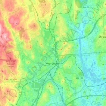
Name: Worcester topographic map, elevation, terrain.
Location: Worcester, Worcester County, Massachusetts, United States (42.21004 -71.88404 42.34119 -71.73124)
Average elevation: 610 ft
Minimum elevation: 341 ft
Maximum elevation: 1,191 ft
Worcester County trails, hiking, mountain biking, running and outdoor activities
Make a donation
Gear up for your next adventure:
As an Amazon Associate, this site earns from qualifying purchases at no extra cost to you.
Other topographic maps
Click on a map to view its topography, its elevation and its terrain.
Hadwen Park
United States > Massachusetts > Worcester County > Worcester > Heard Street
Average elevation: 545 ft
Make a donation
Gear up for your next adventure:
As an Amazon Associate, this site earns from qualifying purchases at no extra cost to you.
Make a donation
Gear up for your next adventure:
As an Amazon Associate, this site earns from qualifying purchases at no extra cost to you.
Northbridge Center
United States > Massachusetts > Worcester County > Northbridge
Average elevation: 407 ft
Crow Hill Ledges
United States > Massachusetts > Worcester County > Westminster
Average elevation: 961 ft
Plummers Hill
United States > Massachusetts > Worcester County > Northbridge
Average elevation: 335 ft
Make a donation
Gear up for your next adventure:
As an Amazon Associate, this site earns from qualifying purchases at no extra cost to you.
South Royalston
United States > Massachusetts > Worcester County > Royalston
Average elevation: 942 ft
Phillipston Four Corners
United States > Massachusetts > Worcester County > Phillipston
Average elevation: 1,099 ft
Tatnuck
United States > Massachusetts > Worcester County > Worcester > Tatnuck Square
Average elevation: 725 ft
Make a donation
Gear up for your next adventure:
As an Amazon Associate, this site earns from qualifying purchases at no extra cost to you.
Blackburn Village
United States > Massachusetts > Worcester County > Ashburnham
Average elevation: 1,070 ft
Central (Stanley) Woolen Mill District Park
United States > Massachusetts > Worcester County > Uxbridge
Average elevation: 262 ft
Make a donation
Gear up for your next adventure:
As an Amazon Associate, this site earns from qualifying purchases at no extra cost to you.
Bassets Corner
United States > Massachusetts > Worcester County > Petersham
Average elevation: 1,063 ft
Make a donation
Gear up for your next adventure:
As an Amazon Associate, this site earns from qualifying purchases at no extra cost to you.
Make a donation
Gear up for your next adventure:
As an Amazon Associate, this site earns from qualifying purchases at no extra cost to you.
Wachusett Station
United States > Massachusetts > Worcester County > Fitchburg
Average elevation: 751 ft
Make a donation
Gear up for your next adventure:
As an Amazon Associate, this site earns from qualifying purchases at no extra cost to you.
Thompsons Pond Dam
United States > Massachusetts > Worcester County > Spencer
Average elevation: 912 ft
Institute Park
United States > Massachusetts > Worcester County > Worcester > Belmont Hill
Average elevation: 558 ft
Make a donation
Gear up for your next adventure:
As an Amazon Associate, this site earns from qualifying purchases at no extra cost to you.
Make a donation
Gear up for your next adventure:
As an Amazon Associate, this site earns from qualifying purchases at no extra cost to you.
Make a donation
Gear up for your next adventure:
As an Amazon Associate, this site earns from qualifying purchases at no extra cost to you.
Make a donation
Gear up for your next adventure:
As an Amazon Associate, this site earns from qualifying purchases at no extra cost to you.
Make a donation
Gear up for your next adventure:
As an Amazon Associate, this site earns from qualifying purchases at no extra cost to you.
Make a donation
Gear up for your next adventure:
As an Amazon Associate, this site earns from qualifying purchases at no extra cost to you.
Summit
United States > Massachusetts > Worcester County > Worcester > Summit
Average elevation: 653 ft
Jefferson
United States > Massachusetts > Worcester County > Holden > Jefferson
Average elevation: 814 ft
Make a donation
Gear up for your next adventure:
As an Amazon Associate, this site earns from qualifying purchases at no extra cost to you.
West Upton
United States > Massachusetts > Worcester County > Upton > West Upton
Average elevation: 364 ft
Hadwen Arboretum
United States > Massachusetts > Worcester County > Worcester > Main South
Average elevation: 541 ft
South Charlton Reservoir
United States > Massachusetts > Worcester County > Charlton > South Charlton
Average elevation: 666 ft
Martha Templeton Rock
United States > Massachusetts > Worcester County > Southborough
Average elevation: 312 ft
Make a donation
Gear up for your next adventure:
As an Amazon Associate, this site earns from qualifying purchases at no extra cost to you.
Hammond Heights
United States > Massachusetts > Worcester County > Worcester
Average elevation: 568 ft
North Worcester
United States > Massachusetts > Worcester County > Worcester
Average elevation: 709 ft
Make a donation
Gear up for your next adventure:
As an Amazon Associate, this site earns from qualifying purchases at no extra cost to you.
Turkey Hill Shores
United States > Massachusetts > Worcester County > Rutland
Average elevation: 1,024 ft