
Claverley topographic map
Click on the map to display elevation.
About this map
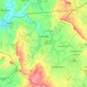
Name: Claverley topographic map, elevation, terrain.
Location: Claverley, Shropshire, England, United Kingdom (52.49448 -2.35571 52.56921 -2.25641)
Average elevation: 289 ft
Minimum elevation: 115 ft
Maximum elevation: 561 ft
Other topographic maps
Click on a map to view its topography, its elevation and its terrain.
Minton
United Kingdom > England > Shropshire > Church Stretton > Little Stretton
Average elevation: 892 ft
Cothercott Hill
United Kingdom > England > Shropshire > Church Pulverbatch
Average elevation: 1,122 ft