Geolocate

Pontiac topographic map

Click on the map to display elevation.

About this map

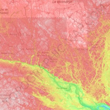
Name: Pontiac topographic map, elevation, terrain.

Location: Pontiac, Outaouais, Quebec, Canada (45.45678 -77.93161 47.28922 -76.14891)

Average elevation: 1,020 ft

Minimum elevation: 177 ft

Maximum elevation: 1,834 ft

Other topographic maps

Click on a map to view its topography, its elevation and its terrain.

Danford Lake

Canada > Quebec > Pontiac > Alleyn-et-Cawood

Average elevation: 689 ft

Iron Hill

Canada > Quebec > Brome-Missisquoi > Lac-Brome

Average elevation: 804 ft

Lac Foncines

Canada > Quebec > Le Domaine-du-Roy > Lac-Ashuapmushuan

Average elevation: 1,591 ft

Lac Marsal

Canada > Quebec > Le Domaine-du-Roy > Lac-Ashuapmushuan

Average elevation: 1,368 ft

Leggatt

Canada > Quebec > La Mitis > Grand-Métis

Average elevation: 200 ft

Lac Manon

Canada > Quebec > Le Fjord-du-Saguenay > Mont-Valin

Average elevation: 1,831 ft

Lac Farmer

Canada > Quebec > Les Pays-d'en-Haut > Wentworth-Nord

Average elevation: 1,079 ft

Val-d'Espoir

Canada > Quebec > Le Rocher-Percé > Percé

Average elevation: 446 ft

Mont Veyrier

Canada > Quebec > Manicouagan > Rivière-aux-Outardes

Average elevation: 3,232 ft

Languedoc

Canada > Quebec > Abitibi-Ouest > Rivière-Ojima

Average elevation: 1,010 ft

Lac Doré

Canada > Quebec > La Haute-Côte-Nord > Lac-au-Brochet

Average elevation: 1,919 ft

Lac Xavier

Canada > Quebec > Les Laurentides > La Conception

Average elevation: 968 ft

Lac Cabot

Canada > Quebec > Urban agglomeration of La Tuque > La Tuque

Average elevation: 1,490 ft

Lac Lili

Canada > Quebec > Matawinie > Chertsey

Average elevation: 1,158 ft

The Edge

Canada > Quebec > Les Laurentides > Mont-Tremblant

Average elevation: 2,254 ft

Lac Frime

Canada > Quebec > Antoine-Labelle > Lac-Marguerite

Average elevation: 804 ft

Sainte-Julie-Station

Canada > Quebec > L'Érable > Laurierville

Average elevation: 482 ft

Île de l'Est

Canada > Quebec > Eeyou Istchee

Average elevation: 1,237 ft

Île aux Cochons

Canada > Quebec > Abitibi-Ouest > Duparquet

Average elevation: 988 ft

Le Morne

Canada > Quebec > Sainte-Rose-de-Watford

Average elevation: 1,198 ft

Hemmingford

Canada > Quebec > Hemmingford (village) > Hemmingford

Average elevation: 233 ft

AWOS

Canada > Quebec > Longueuil

Average elevation: 89 ft

Knowlton

Canada > Quebec > Lac-Brome > Knowlton

Average elevation: 768 ft

Covey Hill

Canada > Quebec > Havelock

Average elevation: 928 ft

Gaspésie

Canada > Quebec > Mont-Albert

Average elevation: 1,506 ft

Lac Brunet

Canada > Quebec > La Tuque

Average elevation: 968 ft

Shawinigan

Canada > Quebec > Shawinigan

Average elevation: 456 ft

Lac-David

Canada > Quebec > Matawinie > Chertsey > Lac-David

Average elevation: 1,207 ft

Colonie-Cinq

Canada > Quebec > Rouyn-Noranda > Cléricy

Average elevation: 925 ft

Guyenne

Canada > Quebec > Abitibi > Lac-Chicobi > Guyenne

Average elevation: 1,030 ft

Lac Belec

Canada > Quebec > Le Domaine-du-Roy > Lac-Ashuapmushuan

Average elevation: 1,424 ft

Sept-Îles

Canada > Quebec > Sept-Rivières > Sept-Îles

Average elevation: 213 ft

Rouyn-Noranda

Canada > Quebec > Rouyn-Noranda > Rouyn-Noranda

Average elevation: 1,001 ft

Mount Loyal

Canada > Quebec > Matawinie > Rawdon

Average elevation: 722 ft

Mansonville

Canada > Quebec > Memphrémagog > Potton

Average elevation: 692 ft

Lac Besson

Canada > Quebec > Les Laurentides > Montcalm

Average elevation: 1,184 ft

Gear up for your next adventure:

🥇GPS Hiking Watch - Multi‑sport GPS watch with navigation and trail tracking
Backpacking Tent - Lightweight and durable tent for multi‑day hikes
🎒Outdoor Daypacks - Lightweight backpacks designed for carrying maps and essential gear
🏕️Tent Footprint - Protect your tent base from wear
🔊Portable Camp Speaker - Music and alerts at camp

As an Amazon Associate, this site earns from qualifying purchases at no extra cost to you.