Geolocate

Cuautla topographic map

Click on the map to display elevation.

About this map

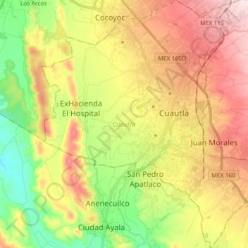
Name: Cuautla topographic map, elevation, terrain.

Location: Cuautla, Morelos, Mexico (18.75489 -99.02019 18.89073 -98.88733)

Average elevation: 4,304 ft

Minimum elevation: 3,698 ft

Maximum elevation: 4,974 ft

Other topographic maps

Click on a map to view its topography, its elevation and its terrain.

Ticumán

Mexico > Morelos > Tlaltizapán de Zapata

Average elevation: 3,497 ft

Cuernavaca

Mexico > Morelos > Cuernavaca

The city is located in a tropical region, but its temperature is fairly constant at 21–26 °C (70–79 °F). It is located on the southern slope of the Sierra de Chichinautzin mountains. In the morning, warm air flows up the mountains from the valley below and in the late afternoon, cooler air flows down…

Average elevation: 5,978 ft

Tepoztlán

Mexico > Morelos > Tepoztlán

Average elevation: 6,027 ft

San Andrés de la Cal

Mexico > Morelos > Tepoztlán

Average elevation: 5,105 ft

San Pedro Apatlaco

Mexico > Morelos > Ayala

Average elevation: 4,183 ft

San Miguel Acapantzingo

Mexico > Morelos > Cuernavaca

Average elevation: 4,774 ft

Anenecuilco

Mexico > Morelos > Ayala

Average elevation: 4,144 ft

Tehuixtla

Mexico > Morelos > Jojutla

Average elevation: 3,005 ft

Tlaltizapan

Mexico > Morelos > Tlaltizapán de Zapata

Average elevation: 3,330 ft

Cuernavaca

Mexico > Morelos > Cuernavaca

The city is located in a tropical region, but its temperature is fairly constant at 21–26 °C (70–79 °F). It is located on the southern slope of the Sierra de Chichinautzin mountains. In the morning, warm air flows up the mountains from the valley below and in the late afternoon, cooler air flows down…

Average elevation: 5,978 ft

Pueblo Viejo

Mexico > Morelos > Temixco

Average elevation: 4,432 ft

Tetela Del Monte

Mexico > Morelos > Cuernavaca

Average elevation: 5,974 ft

San Rafael Zaragoza

Mexico > Morelos > Tlaltizapán de Zapata

Average elevation: 3,445 ft

Santo Domingo Ocotitlán

Mexico > Morelos > Tepoztlán

Average elevation: 7,379 ft

Gear up for your next adventure:

🦶Carbon Trekking Poles - Reduce knee impact on steep descents with ultra-light poles
🔭Telescopic Hiking Pole - Adjustable pole for hiking stability
🎒Gear Packing Cubes - Organize your backpack efficiently
📷Action Cameras - Rugged cameras to document your journeys across rugged terrain
📦Gear Storage Bags - Organize and protect outdoor equipment

As an Amazon Associate, this site earns from qualifying purchases at no extra cost to you.