Geolocate

Defence Colony Tehsil topographic map

Click on the map to display elevation.

About this map

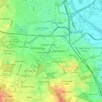
Name: Defence Colony Tehsil topographic map, elevation, terrain.

Location: Defence Colony Tehsil, South East Delhi, Delhi, India (28.52138 77.19884 28.60986 77.30242)

Average elevation: 719 ft

Minimum elevation: 653 ft

Maximum elevation: 840 ft

Other topographic maps

Click on a map to view its topography, its elevation and its terrain.

D1 Janakpuri Park

India > Delhi > New Delhi

Average elevation: 719 ft

M Block Market

India > Delhi > Kalkaji Tehsil

Average elevation: 735 ft

Mehrauli

India > Delhi > Mehrauli Tehsil > Mehrauli

Average elevation: 830 ft

Narela

India > Delhi > Narela Tehsil

Average elevation: 712 ft

Samaspur

India > Delhi > Mayur Vihar Tehsil > Samaspur

Average elevation: 673 ft

Hauz Rani

India > Delhi > Hauz Khas Tehsil

Average elevation: 755 ft

Gear up for your next adventure:

🏕️Family Camping Gear - Essentials for group camping trips
🔦LED Headlamp - Bright and durable LED headlamp for night navigation
🏕️Tent Footprint - Protect your tent base from wear
🧣Hiking Neck Gaiter - Multi‑use neck protection for outdoor weather
🧼Biodegradable Camping Soap - Eco‑friendly soap for outdoor hygiene

As an Amazon Associate, this site earns from qualifying purchases at no extra cost to you.