
Make a donation
Gear up for your next adventure:
As an Amazon Associate, this site earns from qualifying purchases at no extra cost to you.
Luanda Province topographic map
Click on the map to display elevation.
Make a donation
Gear up for your next adventure:
As an Amazon Associate, this site earns from qualifying purchases at no extra cost to you.
About this map
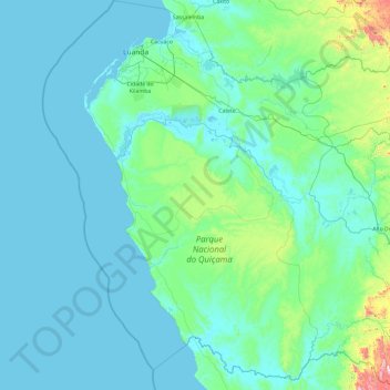
Name: Luanda Province topographic map, elevation, terrain.
Location: Luanda Province, Angola (-10.45624 12.78978 -8.58002 14.62167)
Average elevation: 282 ft
Minimum elevation: -7 ft
Maximum elevation: 3,839 ft
Make a donation
Gear up for your next adventure:
As an Amazon Associate, this site earns from qualifying purchases at no extra cost to you.
Other topographic maps
Click on a map to view its topography, its elevation and its terrain.
Saurimo
Saurimo is located in northeastern Angola at an elevation of 1,084 m (3,556 ft) above sea level. It is a garrison town and local market center.
Average elevation: 3,497 ft
Make a donation
Gear up for your next adventure:
As an Amazon Associate, this site earns from qualifying purchases at no extra cost to you.
Cuito
The town sits on the eastern flank of the Bie Plateau. The climate is unusually cool for its tropical location. The average annual temperature is 18 °C, largely due to its high altitude. The coolest period is May to August when almost no rain falls. September and October are the hottest months with a little…
Average elevation: 5,482 ft
Make a donation
Gear up for your next adventure:
As an Amazon Associate, this site earns from qualifying purchases at no extra cost to you.
Make a donation
Gear up for your next adventure:
As an Amazon Associate, this site earns from qualifying purchases at no extra cost to you.