
San Diego County topographic map
Interactive map
Click on the map to display elevation.
About this map
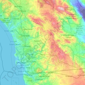
Name: San Diego County topographic map, elevation, terrain.
Location: San Diego County, California, United States (32.52952 -117.61054 33.50524 -116.08109)
Average elevation: 1,785 ft
Minimum elevation: -233 ft
Maximum elevation: 8,474 ft
San Diego County has a varied topography. On its western side is more than 70 miles (113 km) of coastline. Most of San Diego between the coast and the Laguna Mountains consists of hills, mesas, and small canyons. Snow-capped (in winter) mountains rise to the east, with the Sonoran Desert farther to the east. Cleveland National Forest is spread across the central portion of the county, while the Anza-Borrego Desert State Park occupies most of the northeast.
Other topographic maps
Click on a map to view its topography, its elevation and its terrain.
San Diego
United States > California > San Diego County
San Diego, San Diego County, California, United States
Average elevation: 410 ft
San Francisco
San Francisco, California, United States
Average elevation: 207 ft
Los Angeles
United States > California > Los Angeles County
Los Angeles, Los Angeles County, California, United States
Average elevation: 791 ft
Sacramento
United States > California > Sacramento County
Sacramento, Sacramento County, California, United States
Average elevation: 33 ft
Lake Tahoe
United States > California > Placer County
Lake Tahoe, Placer County, California, United States
Average elevation: 6,814 ft
Berkeley
United States > California > Alameda County
Berkeley, Alameda County, California, United States
Average elevation: 358 ft
Eureka
United States > California > Humboldt County
Eureka, Humboldt County, California, United States
Average elevation: 59 ft
Butte County
Butte County, California, United States
Average elevation: 1,995 ft
Copperopolis
United States > California > Calaveras County
Copperopolis, Calaveras County, California, 95228, United States
Average elevation: 997 ft
Yosemite National Park
United States > California > Mariposa County
Yosemite National Park, Mariposa County, California, United States
Average elevation: 7,667 ft
Alameda
United States > California > Alameda County
Alameda, Alameda County, California, United States
Average elevation: 30 ft
Death Valley National Park
Death Valley National Park, California, 92328, United States
Average elevation: 3,842 ft
San Marcos
United States > California > San Diego County
San Marcos, San Diego County, California, United States
Average elevation: 719 ft
Altadena
Altadena, California, 91001, United States
Average elevation: 1,709 ft
La Jolla
United States > California > San Diego County > San Diego > La Jolla
La Jolla, San Diego, San Diego County, California, 92037, United States
Average elevation: 121 ft
Sonora
United States > California > Tuolumne County
Sonora, Tuolumne County, California, United States
Average elevation: 2,018 ft
Mount Shasta
United States > California > Siskiyou County
Mount Shasta, Siskiyou County, California, United States
Average elevation: 12,195 ft
San Jose
United States > California > Santa Clara County > San Jose
San Jose, Santa Clara County, California, 95113, United States
Average elevation: 696 ft
Mammoth Lakes
United States > California > Mono County
Mammoth Lakes, Mono County, California, 93546, United States
Average elevation: 8,799 ft
San Fernando Valley
United States > California > Los Angeles
San Fernando Valley, Lake Balboa Neighborhood Council District, Los Angeles City Council District 6, Los Angeles, California, 91406, United States
Average elevation: 794 ft
Los Angeles County
Los Angeles County, California, United States
Average elevation: 1,240 ft
Santa Clara County
Santa Clara County, California, United States
Average elevation: 1,060 ft
Auburn
United States > California > Placer County
Auburn, Placer County, California, 95603, United States
Average elevation: 1,247 ft
Bakersfield
United States > California > Kern County
Bakersfield, Kern County, California, United States
Average elevation: 515 ft
Poway
United States > California > San Diego County
Poway, San Diego County, California, 92064, United States
Average elevation: 902 ft
South Lake Tahoe
United States > California > El Dorado County
South Lake Tahoe, El Dorado County, California, United States
Average elevation: 6,493 ft
Sonoma County
Sonoma County, California, United States
Average elevation: 689 ft
Modesto
United States > California > Stanislaus County
Modesto, Stanislaus County, California, United States
Average elevation: 85 ft
Napa County
Napa County, California, United States
Average elevation: 761 ft
Livermore
United States > California > Alameda County
Livermore, Alameda County, California, 94550, United States
Average elevation: 604 ft
Oakland
United States > California > Alameda County
Oakland, Alameda County, California, United States
Average elevation: 167 ft
Santa Cruz Mountains
United States > California > Santa Clara County
Santa Cruz Mountains, Santa Clara County, CAL Fire Northern Region, California, United States
Average elevation: 755 ft
Orange County
Orange County, California, United States
Average elevation: 367 ft
Sacramento County
Sacramento County, California, United States
Average elevation: 203 ft
Pacific Grove
United States > California > Monterey County
Pacific Grove, Monterey County, California, 93950, United States
Average elevation: 46 ft
Walnut Creek
United States > California > Contra Costa County
Walnut Creek, Contra Costa County, California, United States
Average elevation: 390 ft
Truckee
United States > California > Nevada County
Truckee, Nevada County, California, United States
Average elevation: 6,293 ft
Fallbrook
United States > California > San Diego County
Fallbrook, San Diego County, California, 92028, United States
Average elevation: 659 ft
Imperial County
Imperial County, California, United States
Average elevation: 623 ft
Rancho Palos Verdes
Rancho Palos Verdes, California, 90274, United States
Average elevation: 171 ft
Griffith Park
United States > California > Los Angeles County > Los Angeles
Griffith Park, Los Angeles, Los Angeles County, CAL Fire Southern Region, California, United States
Average elevation: 725 ft
Encinitas
United States > California > San Diego County
Encinitas, San Diego County, California, United States
Average elevation: 105 ft
Escondido
United States > California > San Diego County
Escondido, San Diego County, California, United States
Average elevation: 896 ft
Temecula
United States > California > Riverside County
Temecula, Riverside County, California, United States
Average elevation: 1,270 ft
Pasadena
Pasadena, Los Angeles County, California, United States
Average elevation: 1,804 ft
Thermal
United States > California > Riverside County
Thermal, Riverside County, California, United States
Average elevation: -118 ft
Kings Canyon National Park
United States > California > Fresno County
Kings Canyon National Park, Fresno County, California, 93633, United States
Average elevation: 8,501 ft
Lake Arrowhead
United States > California > San Bernardino County
Lake Arrowhead, San Bernardino County, California, United States
Average elevation: 5,262 ft
Diamond Bar
Diamond Bar, California, 91765, United States
Average elevation: 906 ft
Santa Catalina Island
United States > California > Los Angeles County > Avalon
Santa Catalina Island, Avalon, Los Angeles County, California, 90704, United States
Average elevation: 197 ft