
East Sussex topographic map
Interactive map
Click on the map to display elevation.
About this map
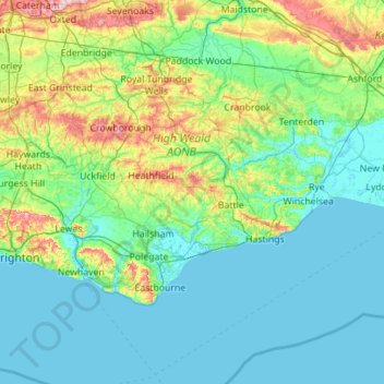
Name: East Sussex topographic map, elevation, terrain.
Location: East Sussex, England, United Kingdom (50.73343 -0.24508 51.14746 0.86786)
Average elevation: 144 ft
Minimum elevation: -7 ft
Maximum elevation: 886 ft
The chalk uplands of the South Downs occupies the coastal strip between Brighton and Eastbourne. There are two river gaps: the Rivers Ouse and Cuckmere. The Seven Sisters, where the Downs meet the sea, are the remnants of dry valleys cut into the chalk; they end at Beachy Head, 530 feet (162 m) above sea level. To the east of Beachy Head lie the marshlands of the Pevensey Levels, formerly flooded by the sea but now enclosed within a deposited beach. At Bexhill the land begins to rise again where the sands and clays of the Weald meet the sea; these culminate in the sandstone cliffs east of Hastings. Further east are the Pett Levels, more marshland, beyond which is the estuary of the River Rother. On the far side of the estuary are the dunes of Camber Sands. The highest point in the county is Ditchling Beacon on the South Downs, which has a maximum elevation of 248 m (814 ft) and is classed as a Marilyn.
Other topographic maps
Click on a map to view its topography, its elevation and its terrain.
Plumpton Green
United Kingdom > England > East Sussex > Lewes
Plumpton Green, Lewes, East Sussex, England, BN7 3BU, United Kingdom
Average elevation: 148 ft
Mark Cross
United Kingdom > England > East Sussex > Wealden
Mark Cross, Wealden, East Sussex, England, TN6 3PL, United Kingdom
Average elevation: 433 ft
Newhaven
United Kingdom > England > East Sussex > Mount Pleasant
Newhaven, Mount Pleasant, Lewes, East Sussex, England, United Kingdom
Average elevation: 62 ft
Hailsham
United Kingdom > England > East Sussex > Wealden > Hailsham
Hailsham, Wealden, East Sussex, England, United Kingdom
Average elevation: 46 ft
Norton Pond
United Kingdom > England > East Sussex > Lewes > Mount Pleasant
Norton Pond, South Heighton, Mount Pleasant, Lewes, East Sussex, England, United Kingdom
Average elevation: 138 ft
Brighton
United Kingdom > England > East Sussex
Brighton, East Sussex, England, BN1 1HH, United Kingdom
Average elevation: 92 ft
Wych Cross
United Kingdom > England > East Sussex > Wealden
Wych Cross, Forest Row, Wealden, East Sussex, England, RH18 5JL, United Kingdom
Average elevation: 486 ft
Fletching
United Kingdom > England > East Sussex > Wealden > Fletching
Fletching, Wealden, East Sussex, England, United Kingdom
Average elevation: 154 ft
Nash Street
United Kingdom > England > East Sussex > Wealden > Muddles Green
Nash Street, Chiddingly, Muddles Green, Wealden, East Sussex, England, BN27 4AB, United Kingdom
Average elevation: 102 ft
Ouse Valley
United Kingdom > England > East Sussex > Newhaven > Mount Pleasant
Ouse Valley, The Drove, Newhaven, Mount Pleasant, Lewes, East Sussex, England, BN9 0AG, United Kingdom
Average elevation: 49 ft
Rye Harbour
United Kingdom > England > East Sussex > Rother
Rye Harbour, Rother, East Sussex, England, TN31 7HX, United Kingdom
Average elevation: 7 ft
Pevensey
United Kingdom > England > East Sussex > Wealden > Pevensey
Pevensey, Wealden, East Sussex, England, United Kingdom
Average elevation: 13 ft
Highwoods SSSI
United Kingdom > England > East Sussex > Rother > Bexhill-on-Sea
Highwoods SSSI, Bexhill-on-Sea, Rother, East Sussex, England, United Kingdom
Average elevation: 92 ft
Bexhill-on-Sea
United Kingdom > England > East Sussex > Rother
Bexhill-on-Sea, Rother, East Sussex, England, TN39 3PE, United Kingdom
Average elevation: 43 ft
Hastings
United Kingdom > England > East Sussex
Hastings, East Sussex, England, United Kingdom
Average elevation: 118 ft
Brede
United Kingdom > England > East Sussex > Rother District
Brede, Rother District, East Sussex, England, United Kingdom
Average elevation: 131 ft
Dripping Well
United Kingdom > England > East Sussex > Hastings
Dripping Well, Barley Lane, Clive Vale, Hastings, East Sussex, England, TN35 5DT, United Kingdom
Average elevation: 266 ft
Bewl Water
United Kingdom > England > East Sussex > Rother District > Ticehurst
Bewl Water, Ticehurst, Rother District, East Sussex, South East England, England, United Kingdom
Average elevation: 302 ft
Rye
United Kingdom > England > East Sussex > Rother > Rye
Rye, Rother, East Sussex, South East England, England, United Kingdom
Average elevation: 23 ft
Crowborough
United Kingdom > England > East Sussex > Wealden District
Crowborough, Wealden District, East Sussex, England, United Kingdom
Average elevation: 479 ft
Chailey
United Kingdom > England > East Sussex > Lewes
Chailey, Lewes, East Sussex, South East England, England, United Kingdom
Average elevation: 131 ft
Battle
United Kingdom > England > East Sussex > Rother > Battle
Battle, Rother, East Sussex, England, United Kingdom
Average elevation: 217 ft
Fairlight
United Kingdom > England > East Sussex > Rother District
Fairlight, Rother District, East Sussex, England, United Kingdom
Average elevation: 154 ft
Icklesham
United Kingdom > England > East Sussex > Rother District
Icklesham, Rother District, East Sussex, England, United Kingdom
Average elevation: 85 ft
Lewes
United Kingdom > England > East Sussex
Lewes, East Sussex, England, United Kingdom
Average elevation: 131 ft
Falmer
United Kingdom > England > East Sussex > Lewes
Falmer, Lewes, East Sussex, England, United Kingdom
Average elevation: 381 ft
Rother
United Kingdom > England > East Sussex
Rother, East Sussex, England, United Kingdom
Average elevation: 118 ft