
Snohomish County topographic map
Click on the map to display elevation.
Snohomish County
The lowland areas of western Snohomish County generally has a temperate Mediterranean climate similar to the rest of the central Puget Sound region with dry summers and wet winters. The county's weather is heavily influenced by maritime systems, pushed by prevailing westerly winds but dampened by the Olympic Mountains. The mean monthly temperatures for the county range from 20 to 40 °F (−7 to 4 °C) during the winter and 55 to 65 °F (13 to 18 °C) in the summer. The record highest temperatures were set during a June 2021 heat wave, with highs of up to 109 °F (43 °C) recorded in several areas. Annual precipitation ranges from 35 inches (89 cm) in the west to 180 inches (460 cm) in the upper elevations of the Cascades; the majority of the region's precipitation falls between October and March. The county's lowlands also has an average annual snowfall ranging from 10 to 20 inches (25 to 51 cm). The Puget Sound Convergence Zone, a known meteorological phenomenon, runs through southwestern Snohomish County and causes narrow bands of precipitation.
About this map
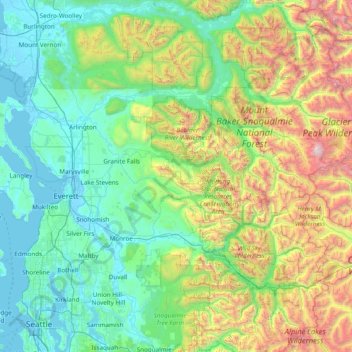
Name: Snohomish County topographic map, elevation, terrain.
Location: Snohomish County, Washington, United States (47.77534 -122.44257 48.29923 -120.90674)
Average elevation: 2,129 ft
Minimum elevation: -13 ft
Maximum elevation: 10,453 ft
Washington trails, hiking, mountain biking, running and outdoor activities
Other topographic maps
Click on a map to view its topography, its elevation and its terrain.
Mount Rainier
United States > Washington > Pierce County
Mount Rainier (/reɪˈnɪər/), indigenously known as Tahoma, Tacoma, Tacobet, or təqʷubəʔ, is a large active stratovolcano in the Cascade Range of the Pacific Northwest, located in Mount Rainier National Park about 59 miles (95 km) south-southeast of Seattle. With a summit elevation of 14,411 ft (4,392…
Average elevation: 12,831 ft
Mount Adams
United States > Washington > Yakima County
Adams is one of the long-lived volcanoes in the Cascade Range, with minor activity beginning 900,000 years ago and major cone building activity beginning 520,000 years ago. The whole mountain has been completely eroded by glaciers to an elevation of 8,200 feet (2,500 m) twice during its lifetime. The current…
Average elevation: 10,614 ft
Mount Saint Helens
United States > Washington > Skamania County
The Mount St. Helens major eruption of May 18, 1980 remains the deadliest and most economically destructive volcanic event in U.S. history. Fifty-seven people were killed; 200 homes, 47 bridges, 15 miles (24 km) of railways, and 185 miles (298 km) of highway were destroyed. A massive debris avalanche,…
Average elevation: 6,877 ft
Stevens Pass
United States > Washington > King County
Stevens Pass (elevation 4,061 ft (1,238 m)) is a mountain pass through the Cascade Mountains located at the border of King County and Chelan County in Washington, United States. U.S. Route 2 travels over the pass, reaching a maximum elevation of 4,061 feet (1,238 m). The Pacific Crest Trail crosses the highway…
Average elevation: 4,551 ft
Glacier Peak
United States > Washington > Snohomish County
Despite its elevation of 10,541 feet (3,213 m), Glacier Peak is a small stratovolcano. Its relatively high summit is a consequence of its location atop a high ridge, but its volcanic portion extends only 1,600–3,200 feet (500–1,000 m) above the underlying ridge. Another Cascade Arc volcano with similar…
Average elevation: 8,714 ft
Goat Peak
United States > Washington > Okanogan County
Goat Peak is a 7,001-foot (2,134 m) peak in the North Cascades of Washington, United States. The summit offers broad views of the Methow River valley, as well as many of the other prominent cascade peaks including glaciated Silver Star Mountain. A working US Forest Service fire lookout is located on the…
Average elevation: 5,440 ft
Mica Peak
United States > Washington > Spokane County
Mica Peak is the name of two separate mountain summits in the United States located approximately 5.49 miles (9 km) apart; one in Spokane County, Washington and the other in Kootenai County, Idaho. The two peaks are located along the same ridge, which separates the Spokane Valley and Rathdrum Prairie from the…
Average elevation: 4,301 ft
Mount Ellinor
United States > Washington > Mason County
Mount Ellinor is a peak in the Olympic Mountains of Washington, United States. It is located in an area designated as the Mount Skokomish Wilderness. The mountain is a popular day hike in the summer months; the summit is reachable via a steep-but-brief 3.3-mile (5.3 km) trail which gains about 3,200 feet (980…
Average elevation: 4,377 ft
Observatory Hill State Park
United States > Washington > Klickitat County > Goldendale
Average elevation: 1,772 ft
Skyline Home Owners Association
United States > Washington > Skagit County > Anacortes
Average elevation: 46 ft
Sahale Mountain
United States > Washington > Skagit County
The North Cascades features some of the most rugged topography in the Cascade Range with craggy peaks and ridges, deep glacial valleys, and granite spires. Geological events occurring many years ago created the diverse topography and drastic elevation changes over the Cascade Range leading to various climate…
Average elevation: 6,995 ft
Salmon Creek Regional Park
United States > Washington > Clark County > Vancouver
Average elevation: 157 ft
West Hylebos Wetlands Park
United States > Washington > King County > Federal Way
Average elevation: 276 ft
Lake River
United States > Washington > Clark County > Ridgefield
Lake River, a "slow, flat slough of the Columbia River", loses only 1 foot (30 cm) in elevation over its entire 11-mile (18 km) course. It flows north, roughly parallel to the Columbia until curving slightly northwest to join it. At times, tidal fluctuations and high flows along the Columbia cause Lake River…
Average elevation: 115 ft
Mount Olympus
United States > Washington > Jefferson County
With notable local relief, Mount Olympus ascends over 2,100 m (6,900 ft) from the 293 m (961 ft) elevation confluence of the Hoh River with Glacier Creek in only 8.8 km (5.5 mi). Mount Olympus has 2,386 m (7,828 ft) of prominence, ranking 5th in the state of Washington.
Average elevation: 6,345 ft