
Tavares topographic map
Click on the map to display elevation.
About this map
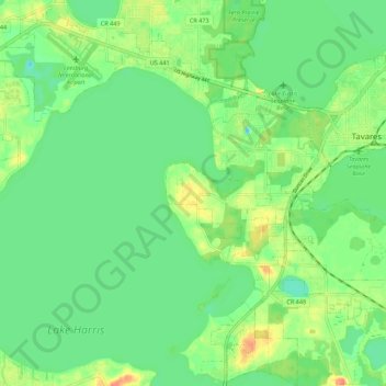
Name: Tavares topographic map, elevation, terrain.
Location: Tavares, Lake County, Florida, 32278, United States (28.74190 -81.78304 28.83820 -81.69152)
Average elevation: 72 ft
Minimum elevation: 16 ft
Maximum elevation: 164 ft
Lake County trails, hiking, mountain biking, running and outdoor activities
Other topographic maps
Click on a map to view its topography, its elevation and its terrain.
Lisbon
United States > Florida > Lake County
Lisbon has low rolling landscape with elevations ranging from 30 ft to 60 ft.
Average elevation: 72 ft