
昌黎县 topographic map
Interactive map
Click on the map to display elevation.
About this map
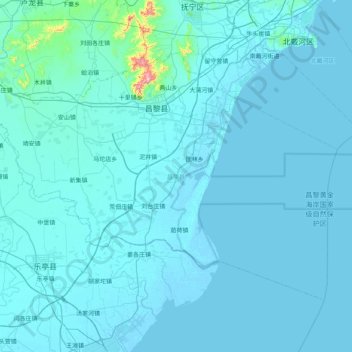
Name: 昌黎县 topographic map, elevation, terrain.
Location: 昌黎县, 秦皇岛市, 河北省, 中国 (39.36297 118.77002 39.80310 119.57760)
Average elevation: 59 ft
Minimum elevation: -10 ft
Maximum elevation: 2,110 ft
位于南部大蒲河镇的大蒲河口附近,是著名的旅游避暑胜地昌黎黄金海岸。昌黎西北有碣石山,主峰海拔695米。
Other topographic maps
Click on a map to view its topography, its elevation and its terrain.