
Make a donation
Gear up for your next adventure:
As an Amazon Associate, this site earns from qualifying purchases at no extra cost to you.
Chinauta topographic map
Click on the map to display elevation.
Make a donation
Gear up for your next adventure:
As an Amazon Associate, this site earns from qualifying purchases at no extra cost to you.
About this map
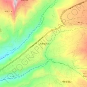
Name: Chinauta topographic map, elevation, terrain.
Average elevation: 4,147 ft
Minimum elevation: 2,425 ft
Maximum elevation: 6,512 ft
Make a donation
Gear up for your next adventure:
As an Amazon Associate, this site earns from qualifying purchases at no extra cost to you.
Other topographic maps
Click on a map to view its topography, its elevation and its terrain.
Cali
La ciudad es plana con una elevación promedia de 1000 msnm. Cali se sitúa además en un punto neurálgico y estratégico: hacia el occidente (aproximadamente 100 km) se conecta con el puerto de Buenaventura sobre el litoral pacífico, y al noreste el centro industrial de Yumbo con el que conforma el Área…
Average elevation: 4,213 ft
Antioquia
La localización de Antioquia en la zona ecuatorial de América influye en las temperaturas promedio de sus regiones, desde temperaturas muy altas en las tierras bajas de Urabá y del Nordeste, así como en las tierras bajas de los valles de los ríos Magdalena, Cauca, Porce y Nechí, hasta las muy frías de…
Average elevation: 1,995 ft
Make a donation
Gear up for your next adventure:
As an Amazon Associate, this site earns from qualifying purchases at no extra cost to you.
Neiva
Debido a su ubicación cerca de la línea del ecuador y su baja altitud, la ciudad tiene se encuentra en el piso térmico cálido con temperaturas anuales promedio durante el día que van desde 21 hasta 35 grado celsius. La variable temperatura siempre guarda cierta relación con la precipitación, de manera…
Average elevation: 3,386 ft
Bogotá
Con la elevación de Bogotá a entidad de primer orden, se dio su separación política, fiscal y administrativa absoluta del departamento de Cundinamarca. Por ello desde la creación del Distrito Especial de Bogotá en 1954 (es decir, cuando se anexan los siete municipios vecinos), el ahora Distrito Capital…
Average elevation: 8,894 ft
Make a donation
Gear up for your next adventure:
As an Amazon Associate, this site earns from qualifying purchases at no extra cost to you.
Dosquebradas
El clima de Dosquebradas es un clima muy variable y agradable, su altitud está entre los 1450 y 2150 m s. n. m., pero su casco urbano tiene un promedio de altura de 1520 m s. n. m., y su temperatura oscila entre los 18 °C y los 30 °C, es frecuentada por lluvias, sobre todo en horas de las tardes, debido a…
Average elevation: 5,361 ft
San Gil
La mayor parte del territorio varía de ondulado a fuertemente ondulado y su relieve corresponde a la cordillera Oriental andina. Sus montañas se levantan al norte hasta el alto de la Legua y sigue elevándose hasta los pozos donde se halla el aeropuerto a una altitud de 1750 metros. Por el oriente se levanta…
Average elevation: 4,938 ft
Make a donation
Gear up for your next adventure:
As an Amazon Associate, this site earns from qualifying purchases at no extra cost to you.
Ubaté
En la provincia Ubaté predominan las tierras de pastos, cuyo uso principal es el pasto manejado, el cual ocupa una extensión 68.024 hectáreas que cubren el 49,6% de la provincia. De igual forma se destacan las extensiones de rastrojo (12,5%), vegetación de páramo (6,5%), bosque plantado (3,9%), papa…
Average elevation: 9,012 ft
Valle del Cauca
Región plana o del Valle físico: Valle entre las cordilleras Central y Occidental de los Andes colombianos. Tiene aproximadamente 240 km de largo y su ancho varía entre 32 km (Yumbo y Palmira) y 12 km (Yotoco y Buga). El valle se encuentra a una altitud de 1000 m s. n. m. en promedio y abarca una superficie…
Average elevation: 2,618 ft
Guarne
La cabecera de Guarne es pequeña, conservando parte de su aspecto colonial, está edificada en la parte occidental de un valle circundado por colinas de pequeña elevación, a una altura de 2280 metros sobre el nivel del mar. Frente a la parte oriental del poblado corre en dirección nordeste el río Mosca,…
Average elevation: 7,454 ft
Make a donation
Gear up for your next adventure:
As an Amazon Associate, this site earns from qualifying purchases at no extra cost to you.
Oiba
Se localiza a unos 1.420 m de altitud, en una cañada que desciende hacia el valle del río San Bartolomé (también denominado Oibita o Llano del Burro), un afluente del Suárez, tributario, a su vez, del Magdalena. La comarca sobre la que se asienta Oiba forma parte de un área amesetada que se extiende…
Average elevation: 5,351 ft
Choachí
La cabecera municipal se encuentra a una altitud de 1924 m, con una temperatura media anual de 18ºC.
Average elevation: 8,842 ft
Make a donation
Gear up for your next adventure:
As an Amazon Associate, this site earns from qualifying purchases at no extra cost to you.
Santander de Quilichao
Topográficamente hay dos zonas bien definidas: la zona plana, donde se inicia el valle geográfico del río Cauca y con explotaciones agropecuarias y tecnologías apropiadas. La zona de ladera: topografía ondulada suave, con diferencia de pisos térmicos que hacen que el establecimiento de actividades…
Average elevation: 4,386 ft
Make a donation
Gear up for your next adventure:
As an Amazon Associate, this site earns from qualifying purchases at no extra cost to you.
El Tambo
Históricamente este territorio es importante por cuanto aquí se llevó a cabo la Batalla de la Cuchilla del Tambo, librada el 29 de junio de 1815 por el ejército patriota que durante tres horas, con 550 infantes, 30 artilleros, 70 caballerías, veteranos y voluntarios comandados por JUAN MARIA MEDINA,…
Average elevation: 4,652 ft
Perímetro Urbano Santa Marta
Colombia > Magdalena > Santa Marta
La temperatura media es de 27º °C, y su temperatura mínima promedio de 23 °C y máxima promedio de 32 °C. En el casco urbano predomina un clima semiárido cálido tropical BShx en la clasificación climática de Köppen, y por la diferencia en la topografía de los demás territorios del municipio se dan…
Average elevation: 702 ft
La Guajira
El departamento está conformado por el Macizo Guajiro al noreste, un macizo antiguo que abarca la península de La Guajira y comprende las serranías de Jarara Cocinas, Carpintero y La Makuira, esta última posee la máxima elevación que alcanza el cerro Palúa con 865 m; además el cerro LaTeta y Huitpana.
Average elevation: 1,063 ft
Make a donation
Gear up for your next adventure:
As an Amazon Associate, this site earns from qualifying purchases at no extra cost to you.
Chía
Colombia > Cundinamarca > Chía
El municipio de Chía está situado en el altiplano cundiboyacense (Cordillera Oriental de los Andes), a una altitud promedio de poco menos de 2600 m s. n. m. El casco urbano cuenta con un área de 17 km² y el área total del municipio es de aproximadamente 79 km².
Average elevation: 8,576 ft
Garzón
Garzón limita por el norte con el municipio de Gigante, por el sur con el municipio de Guadalupe, al suroeste con los municipios de Altamira; por el oriente con el departamento del Caquetá y por el occidente con el municipio de Agrado. Debido a su topografía, se encuentra subdividida en distintas regiones.
Average elevation: 4,482 ft
Make a donation
Gear up for your next adventure:
As an Amazon Associate, this site earns from qualifying purchases at no extra cost to you.
Make a donation
Gear up for your next adventure:
As an Amazon Associate, this site earns from qualifying purchases at no extra cost to you.
Palmira
Los pisos térmicos que se presentan en la ciudad y zona rural de Palmira varían desde el clima frío en el Páramo de las Hermosas hasta la zona cálida del valle del río Cauca; su temperatura en el área urbana va desde los 18 °C a los 37 °C y su altitud es de 1001 metros. En Palmira hay dos zonas…
Average elevation: 5,249 ft
Montes de María
Montes de María (conocidos también como Serranía de San Jacinto) es una cadena montañosa de baja altitud localizada al norte de Colombia. La propia serranía y la zona circundante forma una subregión del Caribe colombiano de 6466 km², ubicada entre los departamentos de Sucre y Bolívar.
Average elevation: 407 ft
Manizales
Manizales cuenta con un aeropuerto nacional llamado Aeropuerto de La Nubia, que cuenta con una pista de aproximadamente 1.400 metros y presta sus servicios de 6 de la mañana a 6 de la tarde. Debido a las condiciones climáticas, a menudo es cerrado por baja visibilidad. Por su parte, la existencia de…
Average elevation: 6,936 ft
Make a donation
Gear up for your next adventure:
As an Amazon Associate, this site earns from qualifying purchases at no extra cost to you.
Meta
El territorio está dividido en tres regiones fisiográficas: la primera la constituye la parte montañosa oriental del departamento justo sobre el costado oriental de la cordillera Oriental, denominada piedemonte llanero, el cual es un sector montañoso y lluvioso con alturas que alcanzan los 4.306 m sobre el…
Average elevation: 1,883 ft
Make a donation
Gear up for your next adventure:
As an Amazon Associate, this site earns from qualifying purchases at no extra cost to you.
Make a donation
Gear up for your next adventure:
As an Amazon Associate, this site earns from qualifying purchases at no extra cost to you.
Montenegro
El municipio de Montenegro se localiza a 10 kilómetros al oeste de Armenia y a 300 kilómetros al suroeste de Bogotá a una altitud de 1.294 m s. n. m., con las coordenadas geográficas 4,34° Latitud Norte y 75,45° Longitud Oeste.
Average elevation: 4,193 ft
Make a donation
Gear up for your next adventure:
As an Amazon Associate, this site earns from qualifying purchases at no extra cost to you.
Girardot
La cabecera municipal está a una altitud de 290 m s. n. m., pero su territorio, de 150 km², abarca 70% de relieve montañoso que alcanza 1000 m s. n. m., dado que se encuentra en un vértice de la Cordillera Oriental colombiana. La máxima temperatura registrada en la historia de Girardot fue de 42,3 °C, y…
Average elevation: 1,175 ft
Make a donation
Gear up for your next adventure:
As an Amazon Associate, this site earns from qualifying purchases at no extra cost to you.
Make a donation
Gear up for your next adventure:
As an Amazon Associate, this site earns from qualifying purchases at no extra cost to you.
San Antero
Está localizado en la región del bajo Sinú, en la parte Norte del departamento. El Municipio se encuentra localizado en la región del bajo Sinú y pegado a la costa del Mar Caribe. Es una zona cálida y de tierras fértiles para la agricultura. La principal característica del territorio de San Antero es…
Average elevation: 102 ft
Make a donation
Gear up for your next adventure:
As an Amazon Associate, this site earns from qualifying purchases at no extra cost to you.
Tolima
Por estar el departamento del Tolima situado en la región del ecuador, no presenta ciclo estacional, pero disfruta de todos los niveles térmicos de montaña. Con cumbres nevadas a más de 5000 metros de altitud con las temperaturas bajo cero como el Nevado del Huila, el Nevado del Tolima, y le pertenecen…
Average elevation: 5,535 ft
Santander
Separadas del cuerpo de la cordillera, al centro del departamento, está un conjunto de montañas de mediana elevación, la Serranía de los Yariguíes. Comprende sectores de los municipios de Zapatoca, Betulia, Galán, El Hato, Palmar, Simacota, Palmas del Socorro, Chima, Contratación, El Guacamayo,…
Average elevation: 4,469 ft
Make a donation
Gear up for your next adventure:
As an Amazon Associate, this site earns from qualifying purchases at no extra cost to you.
Tuluá
De estilo español antiguo, en cruz, el escudo está dividido en cuatro cantones: El cantón diestro del Jefe lleva trece roeles azules o tortillos sobre el campo de plata. Representa el mismo escudo mobiliario de la familia Lemos, en España, por considerar algunos historiadores a Juan de Lemos y Aguirre como…
Average elevation: 5,102 ft
Caldas
En este departamento es posible encontrar todos los pisos térmicos, desde los cálidos valles del río Magdalena y el río Cauca hasta las nieves perpetuas del Nevado del Ruiz. Predomina la topografía montañosa. Según un estudio de la Universidad del Rosario; en el 2014 Caldas fue el tercer departamento…
Average elevation: 5,052 ft
San Francisco
El 29 de enero de 1857 llegó a este caserío una comisión encabezada por el sacerdote de Funza, Pío Molano, su secretario, el alcalde de La Vega y su párroco Santos María Camero, con el objetivo de estudiar la elevación del caserío a cabecera municipal. En el caserío los esperaban los esposos Francisco…
Average elevation: 7,713 ft
Make a donation
Gear up for your next adventure:
As an Amazon Associate, this site earns from qualifying purchases at no extra cost to you.
Bugalagrande
Enclavado a 941 m de altitud, su territorio, bañado por los ríos Bugalagrande, Río Cauca y La Paila, se distribuye en los pisos térmicos cálido, templado y frío.
Average elevation: 3,602 ft
Make a donation
Gear up for your next adventure:
As an Amazon Associate, this site earns from qualifying purchases at no extra cost to you.
Risaralda
El departamento tiene una extensión de 4.140 km². El departamento está conformado por una zona central de topografía ligeramente ondulada a una elevación de 980m en el municipio de La Virginia . Esta zona está bordeada por las cordilleras Central y Occidental, la Central supera los 4.500m en los nevados…
Average elevation: 4,446 ft
Nariño
Nariño presenta una geografía diversa y clima variado según las altitudes: caluroso en la planicie del Pacífico y frío en la parte montañosa, donde vive la mayor parte de la población, situación que se repite en sentido norte-sur. Se caracteriza por su complicada topografía con respecto a otras zonas…
Average elevation: 3,793 ft
Cartago
El municipio se encuentra en el norte del departamento del Valle del Cauca, siendo la puerta de entrada a este por esta zona, y además se encuentra ubicado en la Cordillera Central perteneciente a la Región Andina de Colombia, en una planicie a una altitud de unos 917 m s. n. m. Por el municipio pasan, por…
Average elevation: 3,281 ft
Make a donation
Gear up for your next adventure:
As an Amazon Associate, this site earns from qualifying purchases at no extra cost to you.
Natagaima
Natagaima es un municipio ubicado al sur del departamento del Tolima, Colombia, a orillas del río Magdalena. Fundado en 1606 por Juan de Borja y Armendia, séptimo Presidente de la Real Audiencia de Santafé de Bogotá. Altitud 326 msnm. Temperatura media 29 °C. Festividades: San Juan, 24 de junio. El nombre…
Average elevation: 2,303 ft
Make a donation
Gear up for your next adventure:
As an Amazon Associate, this site earns from qualifying purchases at no extra cost to you.
Arbeláez
Le siguen en orden de importancia las Veredas de El Salitre y Hato Viejo cuyos productores de ganado de doble propósito aportan el 31% de la población animal, 2.500 cabezas - dedicando este mismo porcentaje de su área a la explotación de forrajes, lo cual presenta cierta relevancia dentro del renglón…
Average elevation: 6,453 ft
Simití
La descripción del Esquema de Ordenamiento Territorial, vigente es la siguiente: El municipio de Simití se localiza a 7°, 57 minutos, 23 segundos latitud norte y a 73°, 56 minutos, 46 segundos latitud oeste; cuenta con una extensión de 1.238 Km2 y se ubica a una altitud de 45 metros sobre el nivel medio…
Average elevation: 1,142 ft
Make a donation
Gear up for your next adventure:
As an Amazon Associate, this site earns from qualifying purchases at no extra cost to you.
Armenia
Armenia posee un clima variado gracias a que está a una altitud media de 1483 m.s.n.m., lo que implica que no hayan ni muy altas ni muy bajas temperaturas. La ubicación de la ciudad recibe vientos cálidos provenientes del valle del río Cauca y vientos fríos provenientes del Paramillo del Quindío y la…
Average elevation: 4,275 ft
Villavicencio
Colombia > Meta > Villavicencio
Topográficamente se distinguen dos regiones: una montañosa ubicada al occidente y noroccidente, formada por el costado de la Cordillera Oriental; la otra, una planicie inclinada ligeramente hacia el oriente y el nororiente, corresponde al piedemonte de la cordillera, bordeada al norte por el río Guatiquía.…
Average elevation: 1,480 ft
Make a donation
Gear up for your next adventure:
As an Amazon Associate, this site earns from qualifying purchases at no extra cost to you.
Ginebra
Límites del municipio Norte: Buga (Cuchilla de los Alpes) Sur: El Cerrito (río Zabaletas) Oriente: Guacarí (ríos Guabitas y Puente Rojo) Occidente: Buga y El Cerrito (páramos de Los Domínguez y Pan de Azúcar) Extensión total: 313 km². km² Altitud de la cabecera municipal (metros sobre el nivel del…
Average elevation: 4,357 ft
Pueblo Bello
Pueblo Bello es uno de los 25 municipios colombianos que integran el Departamento del Cesar. Está ubicado sobre la Sierra Nevada de Santa Marta a una altitud de 1200 m.s.n.m. en un estrecho valle de montaña sobre un altiplano. Es importante centro de abasto para la población Indígena de la Sierra y un…
Average elevation: 5,922 ft
Make a donation
Gear up for your next adventure:
As an Amazon Associate, this site earns from qualifying purchases at no extra cost to you.
Valle de Aburrá
Forma parte de la cuenca natural del río Medellín. Este lo recorre de sur a norte, recibiendo una serie de afluentes a lo largo de su recorrido. El Valle tiene una longitud aproximada de 60 kilómetros y una amplitud variable. Está enmarcado por una topografía irregular y pendiente, con alturas que oscilan…
Average elevation: 6,152 ft
La Palma
La Palma es un Municipio ubicado al noroccidente del Departamento de Cundinamarca, a 150 km de Bogotá. Este municipio, tiene 56 veredas, y en el casco urbano hay 20 barrios; limita al norte con el municipio de Yacopí, por el oriente con Topaipí y el Peñón, por el sur con Utica y La Peña, por el occidente…
Average elevation: 4,245 ft
Make a donation
Gear up for your next adventure:
As an Amazon Associate, this site earns from qualifying purchases at no extra cost to you.