
St. Anthony topographic map
Interactive map
Click on the map to display elevation.
About this map
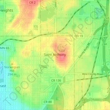
Name: St. Anthony topographic map, elevation, terrain.
Location: St. Anthony, Hennepin County, Minnesota, United States (45.00612 -93.22702 45.05004 -93.20769)
Average elevation: 938 ft
Minimum elevation: 846 ft
Maximum elevation: 1,043 ft
Hennepin County trails, hiking, mountain biking, running and outdoor activities
Other topographic maps
Click on a map to view its topography, its elevation and its terrain.
Minneapolis
United States > Minnesota > Hennepin County > Minneapolis
A 1959 report by the U.S. Soil Conservation Service listed Minneapolis's elevation as 830 feet (250 m). The city's lowest elevation of 687 feet (209 m) above sea level is near where Minnehaha Creek meets the Mississippi River. Sources disagree on the exact location and elevation of the city's highest point,…
Average elevation: 889 ft
Minnehaha Falls
United States > Minnesota > Hennepin County > Minneapolis
Fortunately for the generations to come, in 1883 the state legislature created the Minneapolis Board of Park Commissioners. The board began by acquiring park land near today's downtown Minneapolis. Their choice to hire noted landscape architect Horace Cleveland was fortunate. Cleveland was hired by the Board…
Average elevation: 817 ft
North Commons Park
United States > Minnesota > Hennepin County > Minneapolis
Average elevation: 876 ft
Golden Valley
United States > Minnesota > Hennepin County > Golden Valley > Golden Valley
Average elevation: 906 ft
Maple Grove
United States > Minnesota > Hennepin County > Maple Grove > Maple Grove
Average elevation: 919 ft
Bloomington
United States > Minnesota > Hennepin County > Bloomington > Bloomington
Average elevation: 830 ft
Saint Louis Park
United States > Minnesota > Hennepin County > Saint Louis Park > Saint Louis Park
Average elevation: 899 ft