
Casey Key topographic map
Click on the map to display elevation.
About this map
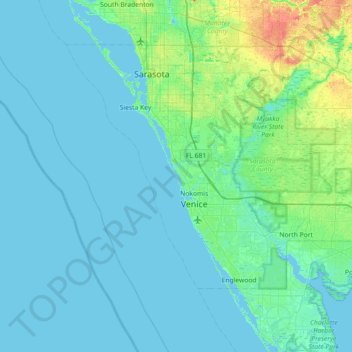
Name: Casey Key topographic map, elevation, terrain.
Location: Casey Key, Sarasota County, Florida, 34274, United States (26.83005 -82.80065 27.47005 -82.16065)
Average elevation: 16 ft
Minimum elevation: -7 ft
Maximum elevation: 115 ft
Sarasota County trails, hiking, mountain biking, running and outdoor activities
Other topographic maps
Click on a map to view its topography, its elevation and its terrain.
Gulf Gate Estates
United States > Florida > Sarasota County > Gulf Gate Estates
Average elevation: 23 ft
South Gate Ridge
United States > Florida > Sarasota County > South Gate Ridge
Average elevation: 39 ft
Ridge Wood Heights
United States > Florida > Sarasota County > Ridge Wood Heights
Average elevation: 33 ft