
Hugo topographic map
Interactive map
Click on the map to display elevation.
About this map
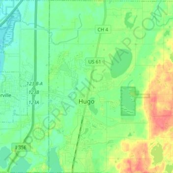
Name: Hugo topographic map, elevation, terrain.
Location: Hugo, Washington County, Minnesota, 55038, United States (45.12355 -93.02044 45.21090 -92.89660)
Average elevation: 932 ft
Minimum elevation: 876 ft
Maximum elevation: 1,050 ft
Washington County trails, hiking, mountain biking, running and outdoor activities
Other topographic maps
Click on a map to view its topography, its elevation and its terrain.
Grey Cloud Island
United States > Minnesota > Washington County > Grey Cloud Island Township
Average elevation: 738 ft
Cottage Grove
United States > Minnesota > Washington County > Cottage Grove > Cottage Grove
Average elevation: 850 ft