Geolocate

Rainbow City topographic map

Interactive map

Click on the map to display elevation.

About this map

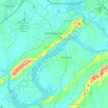
Name: Rainbow City topographic map, elevation, terrain.

Location: Rainbow City, Etowah County, Alabama, 35906, United States (33.86492 -86.16765 33.99262 -86.00425)

Average elevation: 577 ft

Minimum elevation: 482 ft

Maximum elevation: 1,184 ft

Etowah County trails, hiking, mountain biking, running and outdoor activities

Other topographic maps

Click on a map to view its topography, its elevation and its terrain.

Monte Vista

United States > Alabama > Etowah County > Gadsden

Average elevation: 719 ft

Camp Sequoyah Dam

United States > Alabama > Etowah County

Average elevation: 856 ft

Old Harmony

United States > Alabama > Etowah County > Rainbow City

Average elevation: 600 ft

Ballplay

United States > Alabama > Etowah County

Average elevation: 551 ft

Keeling Island

United States > Alabama > Etowah County

Average elevation: 761 ft

Williams

United States > Alabama > Etowah County > Rainbow City

Average elevation: 607 ft

Pilgrims Rest

United States > Alabama > Etowah County > Southside

Average elevation: 581 ft

Gadsden

United States > Alabama > Etowah County > Gadsden > Gadsden

Average elevation: 587 ft

Ridgeville

United States > Alabama > Etowah County

Average elevation: 686 ft

Shiloh

United States > Alabama > Etowah County > Shiloh

Average elevation: 640 ft