
Keeling Island topographic map
Click on the map to display elevation.
About this map
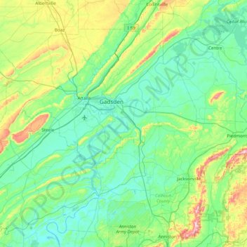
Name: Keeling Island topographic map, elevation, terrain.
Location: Keeling Island, Etowah County, Alabama, 35905, United States (33.63510 -86.28441 34.27510 -85.64441)
Average elevation: 761 ft
Minimum elevation: 456 ft
Maximum elevation: 2,054 ft
Etowah County trails, hiking, mountain biking, running and outdoor activities
Other topographic maps
Click on a map to view its topography, its elevation and its terrain.