Geolocate

Lunenburg topographic map

Click on the map to display elevation.

About this map

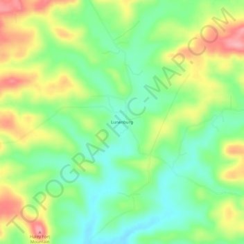
Name: Lunenburg topographic map, elevation, terrain.

Location: Lunenburg, Izard County, Arkansas, United States (35.98257 -91.92765 36.02257 -91.88765)

Average elevation: 525 ft

Minimum elevation: 367 ft

Maximum elevation: 748 ft

Izard County trails, hiking, mountain biking, running and outdoor activities

Other topographic maps

Click on a map to view its topography, its elevation and its terrain.

Mount Pleasant

United States > Arkansas > Izard County

Average elevation: 673 ft

Franklin

United States > Arkansas > Izard County

Average elevation: 666 ft

Guion

United States > Arkansas > Izard County

Average elevation: 466 ft

Pineville

United States > Arkansas > Izard County

Average elevation: 653 ft

Melbourne

United States > Arkansas > Izard County

Average elevation: 659 ft

Gear up for your next adventure:

🪶Thermal Camp Blanket - Extra warmth for cold nights
🎒Trail Energy Bars - High‑calorie bars for hiking energy
🦟Ultrasonic Repellers - Create a bug-free zone at your camp or rest stop
🧺Microfiber Travel Towels - Compact and fast-drying towels for trail use
🧭Hiking Compass - Precision compass for reliable navigation in the wilderness

As an Amazon Associate, this site earns from qualifying purchases at no extra cost to you.