
Victoria topographic map
Click on the map to display elevation.
Victoria
Victoria, Australia, exhibits a remarkably varied topography shaped by the Great Dividing Range, which forms a west-to-east spine across the state. In the northeast, the Victorian Alps rise to the state’s highest point, Mount Bogong at 1,986 meters, amid deep valleys and snow-capped ridges, while westward, the Grampians present rolling hills and striking ridges, peaking at Mount William (1,167 meters). Beyond these highlands, the landscape transitions into the broad, semi-arid plains of the Mallee and Wimmera, contrasting sharply with the fertile volcanic plains and undulating coastal ranges of the south, including the Otways and Strzeleckis. The terrain finally descends toward a diverse coastline of sheer limestone cliffs, sandy beaches, and low-elevation sunklands around Port Phillip Bay, highlighting Victoria’s dramatic shifts from alpine peaks to coastal plains.
About this map
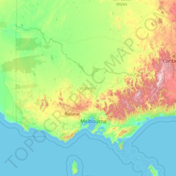
Name: Victoria topographic map, elevation, terrain.
Location: Victoria, Australia (-39.19849 140.96190 -33.98080 150.03328)
Average elevation: 587 ft
Minimum elevation: -7 ft
Maximum elevation: 7,133 ft
Other topographic maps
Click on a map to view its topography, its elevation and its terrain.
Perth
Perth, the capital of Western Australia, is situated on the Swan Coastal Plain, a flat expanse of sandy soil nestled between the Indian Ocean to the west and the Darling Scarp to the east. The Darling Scarp, also known as the Darling Range, is a low escarpment that extends north–south, marking a distinct…
Average elevation: 85 ft
Adelaide
Australia > South Australia > Adelaide
Adelaide is north of the Fleurieu Peninsula, on the Adelaide Plains between the Gulf St Vincent and the low-lying Mount Lofty Ranges. The city stretches 20 km (12 mi) from the coast to the foothills, and 90 km (56 mi) from Gawler at its northern extent to Sellicks Beach in the south. According to the Regional…
Average elevation: 486 ft
Canberra
The area chosen for the capital had been inhabited by Indigenous Australians for up to 21,000 years, with the principal group being the Ngunnawal people. European settlement commenced in the first half of the 19th century, as evidenced by surviving landmarks such as St John's Anglican Church and Blundells…
Average elevation: 2,093 ft
Ballarat
Ballarat has a moderate oceanic climate (Köppen climate classification Cfb) with four distinct seasons. Its elevation, ranging between 400 and 630 metres (1,310 and 2,070 feet) above sea level, causes its mean monthly temperatures to tend to be on average 3 to 5 °C (5 to 9 °F) below those of Melbourne,…
Average elevation: 1,542 ft
Toowoomba
The city occupies the edge of the range and the low ridges behind it. Two valleys run north from the southern boundary, each arising from springs either side of Middle Ridge near Spring Street at an altitude of around 680 m. These waterways, East Creek and West Creek, flow together just north of the CBD to…
Average elevation: 1,503 ft
Great Dividing Range
The Great Dividing Range, also known as the East Australian Cordillera or the Eastern Highlands, is a cordillera system in eastern Australia consisting of an expansive collection of mountain ranges, plateaus and rolling hills, that runs roughly parallel to the east coast of Australia and forms the…
Average elevation: 384 ft
Canberra
The area chosen for the capital had been inhabited by Indigenous Australians for up to 21,000 years, with the principal group being the Ngunnawal people. European settlement commenced in the first half of the 19th century, as evidenced by surviving landmarks such as St John's Anglican Church and Blundells…
Average elevation: 2,093 ft
Hobart
Although Hobart itself rarely receives snow during the winter due to the foehn effect created by the Central Highlands (the city's geographic position causes a rainshadow), the adjacent Kunanyi/Mount Wellington is frequently seen with a snowcap throughout the year including in summer. During the 20th century,…
Average elevation: 587 ft
Launceston
Australia > Tasmania > Launceston
Launceston is at 41°26′31″S 147°8′42″E / 41.44194°S 147.14500°E / -41.44194; 147.14500 in the Tamar Valley, Northern Tasmania. The valley was formed by volcanic and glacial forces over 10 million years ago. The city is about 45 kilometres (28 mi) south of the Bass Strait, with its closest…
Average elevation: 715 ft
Sydney
Phillip had been given no instructions for urban development, but in July 1788 submitted a plan for the new town at Sydney Cove. It included a wide central avenue, a permanent Government House, law courts, hospital and other public buildings, but no provision for warehouses, shops, or other commercial…
Average elevation: 105 ft
Sunshine Coast
Australia > Queensland > Sunshine Coast Regional
The Sunshine Coast in Queensland, Australia, showcases a diverse topography that harmoniously blends coastal plains with rugged hinterlands. Along its eastern edge, the region features expansive sandy beaches and coastal dunes that transition smoothly into fertile lowlands. Inland, the terrain becomes more…
Average elevation: 358 ft
Mount Banks
Mount Banks, otherwise known as Mount King George, is a mountain within the Explorers Range of the Blue Mountains Range that is a spur off the Great Dividing Range, is located within the Blue Mountains National Park, approximately 100 kilometres (62 mi) west of Sydney in New South Wales, Australia. Mount Banks…
Average elevation: 2,444 ft
Rockingham
Australia > Western Australia > Rockingham
Rockingham is topographically flat, has sandy soils and coastal vegetation. It has a northern aspect to Cockburn Sound, from Rockingham Beach and Palm Beach.
Average elevation: 13 ft
Australian Alps
The Australian Alps are a mountain range in southeast Australia. It comprises an interim Australian bioregion, and is the highest mountain range in Australia. The range straddles the borders of eastern Victoria, southeastern New South Wales, and the Australian Capital Territory. It contains Australia's only…
Average elevation: 6,683 ft
Cairns
South of Smithfield and inland from the Northern Beaches along the edge of the Barron River flood plain are the suburbs of Caravonica, Kamerunga, Freshwater, and Stratford. This area is sometimes referred to as Freshwater Valley, though it is actually the lower part of Redlynch Valley; further up the valley…
Average elevation: 577 ft
Melbourne
Melbourne is also prone to isolated convective showers forming when a cold pool crosses the state, especially if there is considerable daytime heating. These showers are often heavy and can include hail, squalls, and significant drops in temperature, but they often pass through very quickly with a rapid…
Average elevation: 161 ft
Stanthorpe
Australia > Queensland > Stanthorpe
Owing to its elevation, Stanthorpe features a subtropical highland climate. At an altitude of 811 metres (2,661 ft), Stanthorpe holds the record for the lowest temperature recorded in Queensland at −10.6 °C (12.9 °F) on 23 June 1961. Sleet and light snowfalls are occasionally recorded, with the most…
Average elevation: 2,756 ft
Caloundra
Caloundra, located on Queensland's Sunshine Coast, features a diverse coastal topography characterized by sandy beaches, rocky headlands, and nearby elevated terrains. The suburb of Kings Beach exemplifies this diversity, with its sandy shoreline to the south and southeast, and a rocky headland rising to about…
Average elevation: 16 ft
Warwick
Australia > Queensland > Warwick
Warwick has a humid subtropical climate (Köppen Cfa) with hot summers and cool to cold winters. It is slightly cooler and less humid than the proximate southeast Queensland coast due to its inland, elevation location. Frost is present in winter. The climate bears similarities with Richmond, an inland suburb…
Average elevation: 1,696 ft
Mount Kosciuszko
Mount Kosciuszko is the highest summit in mainland Australia. Until 1977 it was possible to drive from Charlotte Pass to within a few metres of the summit, but in 1977 the road was closed to public motor vehicle access due to environmental concerns. The road is open from Charlotte Pass for walkers and cyclists…
Average elevation: 6,677 ft
Ballarat
Ballarat has a moderate oceanic climate (Köppen climate classification Cfb) with four distinct seasons. Its elevation, ranging between 400 and 630 metres (1,310 and 2,070 feet) above sea level, causes its mean monthly temperatures to tend to be on average 3 to 5 °C (5 to 9 °F) below those of Melbourne,…
Average elevation: 1,542 ft
Mount Noorat
Mount Noorat is a major volcano of the Newer Volcanics Province of Victoria, with a peak height of 310 metres above sea level and a crater between 160 and 200 metres. It is characterised by multiple vents, a complex topography, and the deepest scoria enclosed crater in Victoria. The mount illustrates a…
Average elevation: 577 ft
Blue Mountains
A sandstone plateau dominated by a landscape of endless eucalyptus forests, the Blue Mountains are located at the top of a 470-million-year-old quartzite. In the Permian period, a shallow sea covered the region, when rivers brought shales, siltstones and mudstones. Then during the Mesozoic period, rivers…
Average elevation: 1,857 ft
Mount Dandenong
Australia > Victoria > Melbourne
Mount Dandenong has a cool oceanic climate (Cfb), with cool to mild summers and cold, damp winters. Daytime temperatures are usually 4−6 °C cooler than downtown Melbourne due to its elevation and distance from the urban heat island effect of Melbourne. It is significantly cloudier than Melbourne,…
Average elevation: 1,296 ft
kunanyi / Mount Wellington
"... In many parts the Eucalypti grew to a great size, and composed a noble forest. In some of the dampest ravines, tree-ferns flourished in an extraordinary manner; I saw one which must have been at least twenty feet high to the base of the fronds, and was in girth exactly six feet. The fronds forming the…
Average elevation: 3,087 ft
Heard Island
Heard Island, by far the largest of the group, is a 368-square-kilometre (142 sq mi) mountainous island covered by 41 glaciers; 80% of the island is covered with ice. The Big Ben massif dominates the island: It has a maximum elevation of 2,745 metres (9,006 ft) at Mawson Peak, the historically active volcanic…
Average elevation: 394 ft