
Make a donation
Gear up for your next adventure:
As an Amazon Associate, this site earns from qualifying purchases at no extra cost to you.
Anguiano topographic map
Click on the map to display elevation.
Make a donation
Gear up for your next adventure:
As an Amazon Associate, this site earns from qualifying purchases at no extra cost to you.
About this map
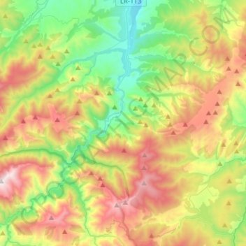
Name: Anguiano topographic map, elevation, terrain.
Location: Anguiano, La Rioja, España (42.19193 -2.93013 42.30946 -2.67719)
Average elevation: 3,533 ft
Minimum elevation: 1,759 ft
Maximum elevation: 6,270 ft
Make a donation
Gear up for your next adventure:
As an Amazon Associate, this site earns from qualifying purchases at no extra cost to you.
Other topographic maps
Click on a map to view its topography, its elevation and its terrain.
Make a donation
Gear up for your next adventure:
As an Amazon Associate, this site earns from qualifying purchases at no extra cost to you.
Make a donation
Gear up for your next adventure:
As an Amazon Associate, this site earns from qualifying purchases at no extra cost to you.
Parque natural de la Sierra Cebollera
España > La Rioja > Lumbreras de Cameros
La Sierra de Cebollera es un enclave geológico privilegiado dentro del Sistema Ibérico, por las formaciones glaciares, los "hoyos", en altitudes superiores a los 2000 metros, como el pico de Peña Cebollera. Por debajo de la alta montaña predominan los extensos bosques naturales de pino silvestre, haya y…
Average elevation: 4,800 ft
Make a donation
Gear up for your next adventure:
As an Amazon Associate, this site earns from qualifying purchases at no extra cost to you.
Make a donation
Gear up for your next adventure:
As an Amazon Associate, this site earns from qualifying purchases at no extra cost to you.
Fuente El Salz
España > La Rioja > Mancomunidad de Nalda, Sorzano y Viguera
Average elevation: 3,530 ft
Make a donation
Gear up for your next adventure:
As an Amazon Associate, this site earns from qualifying purchases at no extra cost to you.
La Villa de Ocón
La Villa de Ocón es una localidad del Valle de Ocón (La Rioja, España), localizada a 36 km de Logroño. Es la localidad más poblada del municipio con 97 habitantes (INE, 2010). Está situada en la ladera sur de un cerro a una altitud de 885 m, en las estribaciones de la sierra de La Hez.
Average elevation: 2,831 ft
Make a donation
Gear up for your next adventure:
As an Amazon Associate, this site earns from qualifying purchases at no extra cost to you.
Make a donation
Gear up for your next adventure:
As an Amazon Associate, this site earns from qualifying purchases at no extra cost to you.
San Vicente de Munilla
España > La Rioja > Munilla > San Vicente de Munilla
Average elevation: 3,186 ft
Make a donation
Gear up for your next adventure:
As an Amazon Associate, this site earns from qualifying purchases at no extra cost to you.
Make a donation
Gear up for your next adventure:
As an Amazon Associate, this site earns from qualifying purchases at no extra cost to you.
Make a donation
Gear up for your next adventure:
As an Amazon Associate, this site earns from qualifying purchases at no extra cost to you.