
Make a donation
Gear up for your next adventure:
As an Amazon Associate, this site earns from qualifying purchases at no extra cost to you.
Neuenkirch topographic map
Click on the map to display elevation.
Make a donation
Gear up for your next adventure:
As an Amazon Associate, this site earns from qualifying purchases at no extra cost to you.
Neuenkirch
Auf einer Anhöhe südwestlich des Sempachersees liegt der Weiler Wartensee (3 km nordwestlich des Dorfs; 559 m ü. M.) mit dem gleichnamigen Schloss.
Make a donation
Gear up for your next adventure:
As an Amazon Associate, this site earns from qualifying purchases at no extra cost to you.
About this map
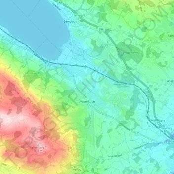
Name: Neuenkirch topographic map, elevation, terrain.
Location: Neuenkirch, Luzern, Schweiz (47.06868 8.15644 47.14463 8.23919)
Average elevation: 1,942 ft
Minimum elevation: 1,637 ft
Maximum elevation: 2,795 ft
Make a donation
Gear up for your next adventure:
As an Amazon Associate, this site earns from qualifying purchases at no extra cost to you.
Other topographic maps
Click on a map to view its topography, its elevation and its terrain.
Make a donation
Gear up for your next adventure:
As an Amazon Associate, this site earns from qualifying purchases at no extra cost to you.
Make a donation
Gear up for your next adventure:
As an Amazon Associate, this site earns from qualifying purchases at no extra cost to you.