Geolocate

Guston topographic map

Click on the map to display elevation.

About this map

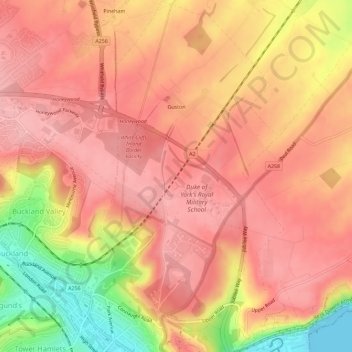
Name: Guston topographic map, elevation, terrain.

Location: Guston, Dover, Kent, England, United Kingdom (51.12853 1.31086 51.16465 1.34163)

Average elevation: 302 ft

Minimum elevation: 0 ft

Maximum elevation: 430 ft

Other topographic maps

Click on a map to view its topography, its elevation and its terrain.

River Stour

United Kingdom > England > Kent > Dover > Ash

Average elevation: 10 ft

Ringwould

United Kingdom > England > Kent > Dover

Average elevation: 148 ft

Waldershare

United Kingdom > England > Kent > Dover > Tilmanstone

Average elevation: 292 ft

Dover Castle

United Kingdom > England > Kent > Dover

Average elevation: 154 ft

Martin

United Kingdom > England > Kent > Dover

Average elevation: 230 ft

Green Lane Hill

United Kingdom > England > Kent > Dover > Whitfield

Average elevation: 305 ft

Elmstone

United Kingdom > England > Kent > Dover > Preston

Average elevation: 43 ft

Wootton

United Kingdom > England > Kent > Dover

Average elevation: 390 ft

Kearsney

United Kingdom > England > Kent > Dover

Average elevation: 308 ft

Sandwich Bay

United Kingdom > England > Kent > Dover

Average elevation: 3 ft

Westmarsh

United Kingdom > England > Kent > Dover > Ash

Average elevation: 26 ft

Ham

United Kingdom > England > Kent > Dover

Average elevation: 52 ft

Shatterling

United Kingdom > England > Kent > Dover > Staple

Average elevation: 59 ft

Church Hougham

United Kingdom > England > Kent > Dover

Average elevation: 292 ft

Hacklinge

United Kingdom > England > Kent > Dover > Worth

Average elevation: 33 ft

Lower Eythorne

United Kingdom > England > Kent > Dover > Eythorne

Average elevation: 246 ft

Wolverton

United Kingdom > England > Kent > Dover > Alkham > Wolverton

Average elevation: 354 ft

South Alkham

United Kingdom > England > Kent > Dover > Alkham > South Alkham

Average elevation: 404 ft

Coldred

United Kingdom > England > Kent > Dover > Shepherdswell > Coldred

Average elevation: 348 ft

Barnsole

United Kingdom > England > Kent > Dover > Staple

Average elevation: 79 ft

Richborough

United Kingdom > England > Kent > Dover

Average elevation: 13 ft

Gear up for your next adventure:

🥄Camping Utensil Set - Lightweight utensils for outdoor meals
🛰️Handheld GPS Units - Professional satellite navigators for precise backcountry mapping
🔥Plasma Lighters - Windproof lighters that work in any weather condition
🪶Camping Sleeping Pad - Comfortable sleeping pad for backpacking
🦶Carbon Trekking Poles - Reduce knee impact on steep descents with ultra-light poles

As an Amazon Associate, this site earns from qualifying purchases at no extra cost to you.