
Make a donation
Gear up for your next adventure:
As an Amazon Associate, this site earns from qualifying purchases at no extra cost to you.
Balaka topographic map
Click on the map to display elevation.
Make a donation
Gear up for your next adventure:
As an Amazon Associate, this site earns from qualifying purchases at no extra cost to you.
About this map
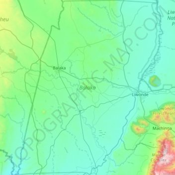
Name: Balaka topographic map, elevation, terrain.
Location: Balaka, Southern Region, Malawi, Malawi (-15.32652 34.81452 -14.77034 35.30057)
Average elevation: 2,047 ft
Minimum elevation: 1,388 ft
Maximum elevation: 6,752 ft
Make a donation
Gear up for your next adventure:
As an Amazon Associate, this site earns from qualifying purchases at no extra cost to you.
Other topographic maps
Click on a map to view its topography, its elevation and its terrain.
Mount Mulanje
Mulanje Massif rises abruptly from the plains to a high plateau at 1800-1900m, surmounted by rocky peaks. Sapitwa Peak is the highest peak on the plateau and the highest peak in Malawi, with an altitude of 3002m above sea level. It is surrounded by densely populated plains situated at 600m-700m above sea level.
Average elevation: 3,796 ft
Mchinji
Mchinji Boma lies at an elevation of 1,182 metres (3,877 ft), 12 kilometres (7.5 mi) from the Zambian border. It is situated 12.4 km (7.7 mi) away from Katambo, 3.5 km (2.2 mi) away from Kadulama Lambo, 2.3 km (1.4 mi) away from Daka and 4.5 km (2.8 mi) away from Tsumba.
Average elevation: 3,967 ft
Make a donation
Gear up for your next adventure:
As an Amazon Associate, this site earns from qualifying purchases at no extra cost to you.
Make a donation
Gear up for your next adventure:
As an Amazon Associate, this site earns from qualifying purchases at no extra cost to you.
Make a donation
Gear up for your next adventure:
As an Amazon Associate, this site earns from qualifying purchases at no extra cost to you.