
Farellones topographic map
Click on the map to display elevation.
Farellones
Located in the commune of Lo Barnechea, 36 km from Santiago at an altitude of 2,340 meters above sea level (7,874 feet), Farellones has a health centre, a school, and about 200 houses. The houses and cabins are made of wood, giving the village its characteristic look.
About this map
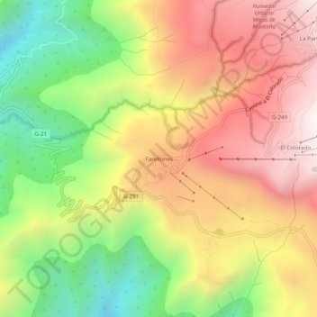
Name: Farellones topographic map, elevation, terrain.
Average elevation: 7,359 ft
Minimum elevation: 5,285 ft
Maximum elevation: 9,301 ft
Other topographic maps
Click on a map to view its topography, its elevation and its terrain.
Santiago
Chile > Santiago Metropolitan Region > Provincia de Santiago
The city lies in the center of the Santiago Basin, a large bowl-shaped valley consisting of broad and fertile lands surrounded by mountains. The city has a varying elevation, gradually increasing from 400 m (1,312 ft) in the western areas to more than 700 m (2,297 ft) in the eastern areas. Santiago's…
Average elevation: 1,814 ft
Mapocho river
Chile > Santiago Metropolitan Region > Provincia de Santiago
Average elevation: 1,932 ft
Recoleta
Chile > Santiago Metropolitan Region > Provincia de Santiago > Santiago
Average elevation: 1,824 ft
Lo Barnechea
Chile > Santiago Metropolitan Region > Provincia de Santiago
Its pre-Hispanic inhabitants were called huaicoches (in Mapudungún: waykoche 'people who live in a landslide zone') because of the huaicos or huaycos of the region (in Quechua: wayqu 'stream'). Also called lloclla (in Quechua: lluqlla 'alluvium'), these are violent alluvial floods in which a large amount of…
Average elevation: 7,818 ft
Quinta Normal
Chile > Santiago Metropolitan Region > Provincia de Santiago
Average elevation: 1,683 ft
Parque Titanium
Chile > Santiago Metropolitan Region > Provincia de Santiago
Average elevation: 2,113 ft
Parque Quinta Normal
Chile > Santiago Metropolitan Region > Provincia de Santiago > Santiago
Average elevation: 1,726 ft
La Reina
Chile > Santiago Metropolitan Region > Provincia de Santiago > Santiago
Average elevation: 2,536 ft
Peñalolén
Chile > Santiago Metropolitan Region > Provincia de Santiago > Santiago
Average elevation: 3,166 ft
La Pintana
Chile > Santiago Metropolitan Region > Provincia de Santiago > La Pintana
Average elevation: 2,051 ft