
Penmorfa topographic map
Click on the map to display elevation.
About this map
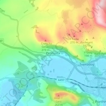
Name: Penmorfa topographic map, elevation, terrain.
Location: Penmorfa, Gwynedd, Wales, LL49 9RU, United Kingdom (52.92391 -4.18266 52.96391 -4.14266)
Average elevation: 358 ft
Minimum elevation: -3 ft
Maximum elevation: 1,135 ft
Other topographic maps
Click on a map to view its topography, its elevation and its terrain.
Morfa Harlech National Nature Reserve
United Kingdom > Wales > Gwynedd > Harlech
Average elevation: 10 ft
Parc Tan-y-Bwlch
United Kingdom > Wales > Gwynedd > Mynydd Llandygái > Pen Y Bwlch
Average elevation: 961 ft
Carneddau
United Kingdom > Wales > Gwynedd > Abergwyngregyn
The plants growing on the Carneddau need to be extremely hardy to withstand the snow, frosts, and gales they will encounter during the year and those found by sheltered streams in the valleys are very different from those clinging to crevices on windswept rocks. Sheep graze the mountains and impact the…
Average elevation: 1,339 ft