Geolocate

Cuenca topographic map

Click on the map to display elevation.

👉 Easily get elevation data in JSON, GeoTIFF and KML formats using Elevation API
Thank you for supporting this site ❤️
Make a donation

About this map

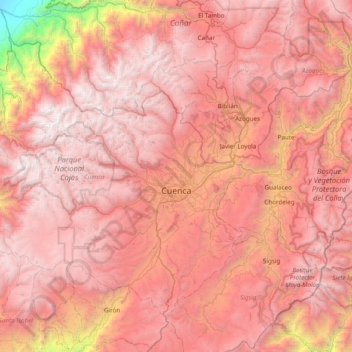
Name: Cuenca topographic map, elevation, terrain.

Location: Cuenca, Azuay, Ecuador (-3.17614 -79.62543 -2.55669 -78.84711)

Average elevation: 8,845 ft

Minimum elevation: 26 ft

Maximum elevation: 14,810 ft

Other topographic maps

Click on a map to view its topography, its elevation and its terrain.

Cochapamba Grande

Ecuador > Azuay > Cuenca > Quingeo

Average elevation: 9,163 ft

Soldados

Ecuador > Azuay > Cuenca > San Joaquín

Average elevation: 11,719 ft

Lentag

Ecuador > Azuay > Girón

Average elevation: 4,931 ft

Don Julo

Ecuador > Azuay > Guachapala > Guachapala

Average elevation: 7,717 ft

Ricaurte

Ecuador > Azuay > Cuenca > Cuenca > Ricaurte

Average elevation: 8,281 ft

Gear up for your next adventure:

🧭Outdoor Navigation Book - Learn advanced navigation skills
🛰️Satellite Messengers - Emergency SOS and two-way messaging for off-grid adventures
🔌Solar Panel Charger - Charge gear sustainably outdoors
🪵Folding Camp Saw - Compact saw for wood and campsite work
🪶Thermal Camp Blanket - Extra warmth for cold nights

As an Amazon Associate, this site earns from qualifying purchases at no extra cost to you.