
New Trier topographic map
Click on the map to display elevation.
About this map
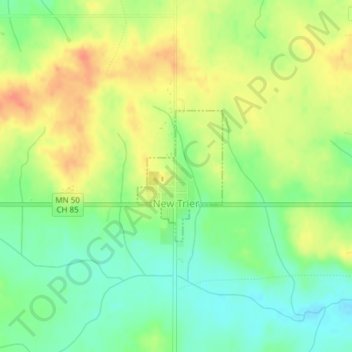
Name: New Trier topographic map, elevation, terrain.
Location: New Trier, Dakota County, Minnesota, United States (44.59842 -92.93819 44.60844 -92.92902)
Average elevation: 984 ft
Minimum elevation: 912 ft
Maximum elevation: 1,056 ft
Dakota County trails, hiking, mountain biking, running and outdoor activities
Other topographic maps
Click on a map to view its topography, its elevation and its terrain.
Chimney Rock Scenic and Natural Area
United States > Minnesota > Dakota County
Average elevation: 883 ft
Burnsville
United States > Minnesota > Dakota County > Burnsville > Burnsville
Average elevation: 902 ft
Farmington
United States > Minnesota > Dakota County > Farmington > Farmington
Average elevation: 919 ft
Lakeville
United States > Minnesota > Dakota County > Lakeville > Lakeville
Average elevation: 1,004 ft
Pig's Eye Island Heron Rookery SNA
United States > Minnesota > Dakota County > South St. Paul
Average elevation: 725 ft