
Make a donation
Gear up for your next adventure:
As an Amazon Associate, this site earns from qualifying purchases at no extra cost to you.
Tenango de Doria topographic map
Click on the map to display elevation.
Make a donation
Gear up for your next adventure:
As an Amazon Associate, this site earns from qualifying purchases at no extra cost to you.
Tenango de Doria
The municipality is located to the east of Hidalgo between the parallels 20° 15’ and 20° 25’ of north latitude; the meridians 98° 05’ and 98° 20’ of west longitude; with an altitude between 700 and 2800 meters above sea level. This municipality has an area of 176. 61 km² and accounts for 0.85% of the state’s area, within the geographical region known as Sierra de Tenango.
Make a donation
Gear up for your next adventure:
As an Amazon Associate, this site earns from qualifying purchases at no extra cost to you.
About this map
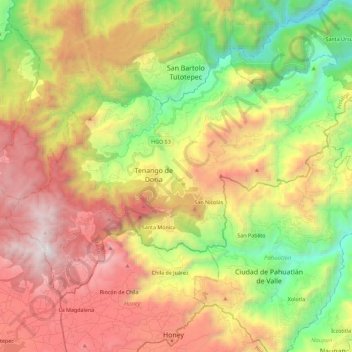
Name: Tenango de Doria topographic map, elevation, terrain.
Location: Tenango de Doria, Hidalgo, Mexico (20.26279 -98.31962 20.41041 -98.09389)
Average elevation: 5,240 ft
Minimum elevation: 1,614 ft
Maximum elevation: 9,370 ft
Make a donation
Gear up for your next adventure:
As an Amazon Associate, this site earns from qualifying purchases at no extra cost to you.
Other topographic maps
Click on a map to view its topography, its elevation and its terrain.
Make a donation
Gear up for your next adventure:
As an Amazon Associate, this site earns from qualifying purchases at no extra cost to you.
Make a donation
Gear up for your next adventure:
As an Amazon Associate, this site earns from qualifying purchases at no extra cost to you.
Make a donation
Gear up for your next adventure:
As an Amazon Associate, this site earns from qualifying purchases at no extra cost to you.
Make a donation
Gear up for your next adventure:
As an Amazon Associate, this site earns from qualifying purchases at no extra cost to you.
Make a donation
Gear up for your next adventure:
As an Amazon Associate, this site earns from qualifying purchases at no extra cost to you.