
Roding topographic map
Click on the map to display elevation.
Roding
Roding besitzt einen Bahnhof an der Bahnstrecke Schwandorf–Cham–Furth im Wald. Er wird von Zügen der Oberpfalzbahn im Stundentakt bedient. Neben Zügen zwischen den beiden Streckenenden halten hier auch einzelne Regionalexpress-Züge Nürnberg–Furth und ALX-Züge München–Prag. Der Bahnhof Roding liegt ca. 3 km nördlich des Ortszentrums. Zwischen diesem Bahnhof und dem Stadtzentrum verkehrt eine Stadtbuslinie. Der Bahnhof wurde 2014 barrierefrei umgebaut. Hierzu wurde der Bahnsteig um 200 m nach Westen verschoben und erhielt einen höhenfreien Zugang, so dass nun bei Zugkreuzungen die Reisendensicherung entfallen konnte.
About this map
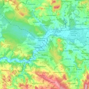
Name: Roding topographic map, elevation, terrain.
Location: Roding, Landkreis Cham, Bayern, 93426, Deutschland (49.13386 12.37079 49.27685 12.56972)
Average elevation: 1,411 ft
Minimum elevation: 1,152 ft
Maximum elevation: 2,073 ft
Other topographic maps
Click on a map to view its topography, its elevation and its terrain.
Burgruine Schwärzenburg
Deutschland > Bayern > Landkreis Cham > Roding > Strahlfeld
Die Höhenburg wurde vermutlich im 13. Jahrhundert auf dem Grund des Bamberger Bischofs von den Herren von Fronau (Adelsgeschlecht), die schon Anfang des 12. Jahrhunderts urkundlich genannt wurden, erbaut. Eine Vorgängeranlage der Höhenburg könnte die Turmhügelburg Haselberg auf dem Gebiet des Haselbergs…
Average elevation: 1,493 ft
Roßweidmühle
Deutschland > Bayern > Landkreis Cham > Miltach > Altrandsberg > Roßweidmühle
Average elevation: 1,594 ft
Schwedenschanze
Deutschland > Bayern > Landkreis Cham > Cham > Chammünster
Der Burgstall Schwedenschanze, bei der es sich vermutlich um die Reichsburg Cham handelt, ist eine abgegangene Höhenburg (Wallburg) auf dem 415 Meter hohen Galgenberg 35 Meter über dem Zusammenfluss von Chamb und Regen in der Gemarkung Altenstadt der Stadt Cham im oberpfälzischen Landkreis Cham in Bayern.…
Average elevation: 1,263 ft