
Make a donation
Gear up for your next adventure:
As an Amazon Associate, this site earns from qualifying purchases at no extra cost to you.
Dorchester topographic map
Click on the map to display elevation.
Make a donation
Gear up for your next adventure:
As an Amazon Associate, this site earns from qualifying purchases at no extra cost to you.
Dorchester
According to the United States Census Bureau, the town has a total area of 45.2 square miles (117.1 km2), of which 44.6 square miles (115.5 km2) are land and 0.62 square miles (1.6 km2) are water, comprising 1.34% of the town. It is drained by the north-flowing South Branch Baker River and the south-flowing Mascoma River and its tributary, the Indian River. Cummins Pond and Reservoir Pond are in the west. The northeastern half of town which drains to the South Branch of the Baker is part of the Merrimack River watershed, while the southwestern half is part of the Connecticut River watershed. The highest point in Dorchester is on its western boundary, where the elevation reaches 3,190 feet (970 m) above sea level, just east of the summit of Smarts Mountain.
Make a donation
Gear up for your next adventure:
As an Amazon Associate, this site earns from qualifying purchases at no extra cost to you.
About this map
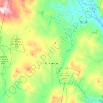
Name: Dorchester topographic map, elevation, terrain.
Location: Dorchester, Grafton County, New Hampshire, United States (43.70581 -72.05818 43.83795 -71.90782)
Average elevation: 1,440 ft
Minimum elevation: 502 ft
Maximum elevation: 3,212 ft
Grafton County trails, hiking, mountain biking, running and outdoor activities
Make a donation
Gear up for your next adventure:
As an Amazon Associate, this site earns from qualifying purchases at no extra cost to you.
Other topographic maps
Click on a map to view its topography, its elevation and its terrain.
Stinson Lake
United States > New Hampshire > Grafton County > Rumney > Stinson Lake
Average elevation: 1,509 ft
Make a donation
Gear up for your next adventure:
As an Amazon Associate, this site earns from qualifying purchases at no extra cost to you.
Make a donation
Gear up for your next adventure:
As an Amazon Associate, this site earns from qualifying purchases at no extra cost to you.
Middle Sugarloaf
United States > New Hampshire > Grafton County > Bethlehem
Average elevation: 1,942 ft
Make a donation
Gear up for your next adventure:
As an Amazon Associate, this site earns from qualifying purchases at no extra cost to you.
Make a donation
Gear up for your next adventure:
As an Amazon Associate, this site earns from qualifying purchases at no extra cost to you.
Campton Lower Village
United States > New Hampshire > Grafton County > Campton
Average elevation: 853 ft
Mount Pemigewasset
United States > New Hampshire > Grafton County > Lincoln
Average elevation: 1,995 ft
Make a donation
Gear up for your next adventure:
As an Amazon Associate, this site earns from qualifying purchases at no extra cost to you.
Campton Hollow
United States > New Hampshire > Grafton County > Campton > Campton Hollow
Average elevation: 823 ft
Make a donation
Gear up for your next adventure:
As an Amazon Associate, this site earns from qualifying purchases at no extra cost to you.
Corcoran Pond
United States > New Hampshire > Grafton County > Waterville Valley
Average elevation: 1,713 ft
Woodstock
United States > New Hampshire > Grafton County > Woodstock > Woodstock
Average elevation: 1,093 ft
Make a donation
Gear up for your next adventure:
As an Amazon Associate, this site earns from qualifying purchases at no extra cost to you.
Make a donation
Gear up for your next adventure:
As an Amazon Associate, this site earns from qualifying purchases at no extra cost to you.
Waterville Valley
United States > New Hampshire > Grafton County > Waterville Valley > Waterville Valley
Average elevation: 1,860 ft
Make a donation
Gear up for your next adventure:
As an Amazon Associate, this site earns from qualifying purchases at no extra cost to you.
Downing Mountain
United States > New Hampshire > Grafton County > Ellsworth
Average elevation: 1,460 ft